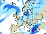
Long-range Outlook: 10/12/05 - 15/12/05
High pressure. Fronts never too far away.
Click here for details of the weather over the next few days.
Please note that forecasting beyond five days is notoriously difficult, and small errors at short-range can lead to large deviations further in time. Our longer-range forecasts are based on the most accurate weather data available at the time, but alterations may be required as the period progresses. Please check back regularly for the most up-to-date forecast run.
Saturday 10/12/05 to Sunday 11/12/05
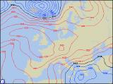
We're still expecting high pressure to persist across the UK on Saturday, although it will be further south than originally forecast. As a result, it will be southern parts of England and Wales that benefit from the driest conditions, with some sunny spells, although it will be frosty at first. Further north across north Wales and northern England, skies will be generally cloudy. Further north still, outbreaks of rain will affect much of Scotland, heavy at times. This rain will extend across Ireland and Northern Ireland, perhaps reaching the west coast of Wales later. Milder for many, although chilly in the south-east. On Sunday, the area of high pressure will ridge westwards, becoming established across Ireland during the day. As a result, the sunniest conditions will be across Ireland, south-west England and south Wales, after a local frost has cleared. Outbreaks of persistent rain will continue across Scotland and Northern Ireland, spreading south into north-west England and north Wales through the day. Remaining parts of England will be cloudy, but mainly dry, and it will be a little milder.
 Monday 12/12/05 to Tuesday 13/12/05
By Monday, the large anticyclone will have become firmly established to the west of the UK. As a result, much of Ireland and Northern Ireland will have an overnight frost, followed by a dry day with sunny spells and variable cloud. The thicker cloud across western parts of England, as well as Wales and western Scotland, will also break to give some sunshine. Across eastern Scotland and eastern parts of England, northerly winds will drag in a good deal of cloud, giving coastal rain and drizzle. There will be very little change in the synoptic situation into Tuesday, as the area of high pressure hardly moves at all. For Ireland, together with western parts of the UK, it will be another dry day with sunny spells developing, after a locally frosty start. Thicker cloud will affect eastern parts of England and Scotland once again, with a continuation of light showers along North Sea coasts. One or two showers are possible through the Irish Sea too, although these will be very isolated.
 Wednesday 14/12/05 to Thursday 15/12/05
Confidence for Wednesday's weather is currently low, as it will very much depend on the behaviour of our resident area of high pressure. At present, we're expecting the high to drift westwards into the Atlantic, allowing a cyclonic north-westerly to blast in to the UK. This will bring outbreaks of rain, heavy at times, across most of Scotland and Northern Ireland during the day. The rest of England, Wales and the Irish Republic will become increasingly cloudy, although it should remain dry. As low pressure develops to the east of the UK during Thursday, a colder northerly flow will develop. This will draw down plenty of showers across the country, most frequent around the coastal fringes. As the day wears on, the showers will turn increasingly wintry across Scotland. However, confidence is currently low surrounding this scenario, so please check back for further forecast updates on next week's weather.