Long-range Outlook: 10/07/04 - 15/07/04
Unsettled with rain or showers, but a chance of summer later next week.
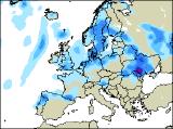
Click here for details of the weather over the next few days.
Please note that forecasting beyond five days is notoriously difficult, and small errors at short-range can lead to large deviations further in time. Our longer-range forecasts are based on the most accurate weather data available at the time, but alterations may be required as the period progresses. Please check back regularly for the most up-to-date forecast run.
Saturday 10/07/04 to Sunday 11/07/04
After an extremely wet and unsettled end to the week, Saturday will be better, if only marginally. Easterly winds across much of eastern England and Scotland will remain fresh, blowing in plenty of heavy, and in places, thundery showers. These showers will also break out across central parts of England, and perhaps east Wales in the afternoon. Western fringes of England and Scotland, along with much of Ireland will have long dry periods with some decent sunny spells. On Sunday, it will be the turn of Ireland, Northern Ireland and south-west England to cloud over, with outbreaks of heavy rain spreading slowly eastwards during the afternoon. The showery weather will become restricted to eastern England and eastern Scotland during the day, such that much of Wales, western parts of England and western Scotland become mostly dry with some warm sunny spells. Feeling cool in the east with the keen easterly breeze continuing.
 Monday 12/07/04 to Tuesday 13/07/04
It will be fairly cool everywhere on Monday, as winds become northerly. In eastern parts, this wind will be fresh, perhaps even strong close to the east coast. Most places will see some bright or sunny spells, but there will also be a good deal of cloud around. This cloud will give showery bursts of rain, especially across Scotland, Northern Ireland, eastern parts of England and north Wales. On Tuesday, eastern areas of England and eastern Scotland will be rather cloudy with outbreaks of showery rain, heavy at times. Further west, there will be some sunny spells, but also a scattering of sharp showers during the afternoon. However, some central parts of both England and Ireland may miss the showers and stay mostly dry. Remaining unseasonably cool with a northerly wind.
 Wednesday 14/07/04 to Thursday 15/07/04
Although it may look as if summer 2004 can be written off, there are promising signs of a change on Wednesday. A ridge of high pressure looks set to build in from the south-west, giving much of Ireland, Wales and south-west England a dry and sunny day. Elsewhere, there will still be the risk of showers, especially across eastern parts once again. With the northerly wind disappearing, it should feel slightly warmer everywhere. On Thursday, outbreaks of showery rain will move into Northern Ireland and western parts of Scotland after a bright morning. Elsewhere however, there's every chance that it will be a dry day with long spells of sunshine. With light south-westerly winds, it may well become very warm, especially in the south. As ever though, please check back for more detail on next week's weather.