Weekly Outlook : 06/08/03-12/08/03
Remaining Hot & Sunny. Cloudier In West By Weekend.
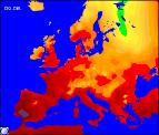 Wednesday 06/08/03 to Thursday 07/08/03
A dull, misty start around south-western coasts, with fog in places. This will clear during the morning, joining the rest of the country with long sunny spells. The exception will be north-eastern parts which may see the odd heavy shower at first. Into the afternoon, the sunshine will continue, but there will be cloud around at times and fog may come and go in the far south-west. Another hot day, with temperatures reaching the mid thirties Celsius in the south. A very sticky night, so hard to sleep once more. Thursday will dawn sunny for most parts, with less in the way of coastal mist in the south-west. Another glorious summer afternoon, with temperatures once more in the thirties in places. The extreme north of Scotland may see more cloud at times, but even here feeling very warm. Head to the coast for sea-breeze relief, where temperatures should remain in the low to mid twenties Celsius.
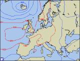 Friday 08/08/03 to Saturday 09/08/03
Little change on Friday, with the summer scorcher continuing. Long sunny spells for many, although the return to coastal sea fog in the west and south-west due to a strengthening southerly wind. Southern England may catch the odd thundery shower in the evening, but this will be the exception. Temperatures reaching the low thirties Celsius in the south, slightly cooler further north. Another muggy night leading into a bright start with further sunshine on Saturday. Today will see the start of a potential change in the west, as a cold front nudges in from the Atlantic across Ireland and Northern Ireland. This will bring increased cloud, and the risk of scattered showers. The rest of mainland UK will remain hot and sultry, with plenty of afternoon sunshine.
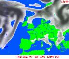 Sunday 10/08/03 to Tuesday 12/08/03
A very complicated situation will be present during Sunday, and the progress of this will determine whether our heat wave continues or fades. Saturday's cold front will continue to push very slowly eastwards, reaching western parts of the mainland UK. However, there is every indication that this will weaken and grind to a halt. Central and eastern parts will remain hot and sunny, and this is expected to last into Monday. Western parts will see more cloud around with the potential for scattered thunderstorms. Beyond Tuesday is extremely uncertain, although our view at the moment sees the cold front nudging westwards once more allowing our summer heat to continue through to mid-week. As ever, further detail on the complex situation will be in the next weekly update.