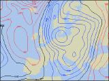
Long-range Outlook: 11/03/05 - 16/03/05
Winter refusing to leave! Snow for many.
Click here for details of the weather over the next few days.
Please note that forecasting beyond five days is notoriously difficult, and small errors at short-range can lead to large deviations further in time. Our longer-range forecasts are based on the most accurate weather data available at the time, but alterations may be required as the period progresses. Please check back regularly for the most up-to-date forecast run.
Friday 11/03/05 to Saturday 12/03/05
Friday will start on an unsettled note, as an active cold front sweeps southwards across the whole country. This will produce some very heavy outbreaks of rain, with very gusty winds and even a risk of thunder, reaching southern England and southern parts of Ireland by late afternoon. Behind this front, northerly winds will bring in much colder air once again, with frequent sleet and snow showers affecting much of Scotland, Northern Ireland and northern England. There will be some sunny spells, but these will be short-lived. Bitterly cold north to north-east winds will blast the country on Saturday, with snow showers extending down the east coast to reach south-east England. Even the sunny spells elsewhere across the UK will trigger some wintry showers during the afternoon. Prolonged spells of snow are possible across parts of Scotland, with blizzard conditions over the hills, although some sheltered southern areas will have plenty of sunshine too. The best of the sunny spells will be across southern parts of Ireland, as well as south Wales and parts of south-west England. Cold everywhere.
 Sunday 13/03/05 to Monday 14/03/05
Strong northerly winds will continue during Sunday, promising a very wintry end to the weekend. Snow showers will be heaviest, and sometimes fairly persistent across eastern England and eastern Scotland, with a covering of snow likely in many areas. Showers will be fewer and further between across central and western England and Wales, although lines of showers are likely to affect Irish Sea coasts. Northern Ireland will bear the brunt of the wintry showers across the water, whilst the Irish Republic, away from the east coast, will remain mostly dry with sunny spells. Little change is expected into Monday, with low pressure to the east of the UK continuing to drag cold north to north-easterly winds across all areas. Sleet and snow showers will again affect many eastern areas, with further accumulations likely. However, another area of rain, sleet and snow will spread southwards across Ireland during the day, perhaps clipping western parts of England and Wales. Confidence of this is uncertain, but this would potentially give an appreciable cover of snow to higher ground.
 Tuesday 15/03/05 to Wednesday 16/03/05
There may be the beginnings of a change by Tuesday, as the cold northerly wind cuts off, allowing a gentle south-westerly drift to develop. There will still be a lot of cold air across the UK and Ireland, so any showers will fall as sleet and snow, especially in eastern areas. However, during the afternoon, more prolonged rain, and at first snow, will slowly spread north-eastwards across England, Wales and Ireland. By Wednesday, it looks like finally becoming milder, as south-westerly winds bring a good deal of cloud and rain across most places. However, this will fall as widespread snow across Scotland during the morning, with disruption possible. With the cold weather having persisted for so many weeks now, confidence of an eventual breakdown is understandably low. Please check back for further forecast update, detailing the weather for next week.