Long-range Outlook: 11/09/04 - 16/09/04
Heavy, thundery showers over the weekend. Often wet & windy next week.
Click here for details of the weather over the next few days.
Please note that forecasting beyond five days is notoriously difficult, and small errors at short-range can lead to large deviations further in time. Our longer-range forecasts are based on the most accurate weather data available at the time, but alterations may be required as the period progresses. Please check back regularly for the most up-to-date forecast run.
Saturday 11/09/04 to Sunday 12/09/04
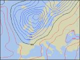
Unsettled weather will be firmly in control on Saturday, as areas of low pressure swing eastwards across the country. Southern and eastern parts of England may have a dry morning, but elsewhere cloud and outbreaks of showery rain will become heavy and more persistent. It will become rather windy across Ireland, Northern Ireland and Wales, and the heaviest rain will fall here during the afternoon. Winds will be lighter elsewhere, but showers will be equally slow-moving. On Sunday, the area of low pressure, together with its weather fronts, will move north-eastwards and clear into the North Sea. Any lingering rain therefore, across eastern Scotland and north-east England will clear away, leaving much of Scotland, England and Wales dry with some sunshine. However, the next area of low pressure will be quickly moving into Ireland and Northern Ireland, bringing with it further outbreaks of heavy rain and strong winds through the afternoon.
 Monday 13/09/04 Tuesday 14/09/04
Low pressure will remain across the UK on Monday, translating into a very unsettled start to the working week. Outbreaks of heavy, driving rain will spread eastwards across England and Wales during the day, becoming slow-moving across south-eastern parts. After a temporarily dry spell across Scotland, Ireland and Northern Ireland, further showers or longer spells of rain will move in from the west. Fresh to strong north-westerly winds will develop, with possible gales in the north-west. There will still be some wet weather around on Tuesday, although any prolonged rain will be reserved for eastern parts initially. Thereafter, most places will see some spells of sunshine, but also a fair number of showers. These will become heavy through the afternoon with hail and thunder, and as westerly winds ease, they will become more slow-moving. Later in the day, more wind and rain will reach western parts of Ireland. Temperatures around average everywhere.
 Wednesday 15/09/04 Thursday 16/09/04
Wednesday will essentially be a dry and sunny day across central and eastern England, although it will cloud over through the afternoon. Elsewhere, any early brightness will soon fade as strong winds and outbreaks of rain sweep in from the west. This will affect Ireland, Northern Ireland and western Scotland initially, where some torrential downpours are likely. This will spread across northern England and Wales through the afternoon, perhaps with the risk of thunder. On Thursday, the extreme south-east of England may still stay dry and fairly bright. Elsewhere, there will be a good deal of cloud with further outbreaks of rain. Much of this rain will be heavy, and there is the potential for some localised flooding across parts of Wales, northern England and Scotland. Later in the day, brighter weather with scattered showers will move in from the west across Ireland. Very windy everywhere, although fairly warm.