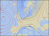
Weekly Outlook : 11/11/04-16/11/04
Becoming colder and more unsettled.
Thursday 11/11/04 to Friday 12/11/04
We're not expecting a good deal of change in the weather setup by Thursday, and this will mean high pressure to the west dominating much of the UK. However, once again there will not be much sunshine around, and the best of this will be across southern parts of Ireland and southern England. Elsewhere there will be largely cloudy skies, with patchy drizzle almost anywhere. Increasing cloud and wind across Scotland will give heavier rain here through the afternoon. Our previous forecast indicated that it would become much colder by Friday, and this still looks to be the case. As high pressure retreats westwards, north to north-westerly winds will blast across most of the UK and Ireland. One band of rain will sink southwards across all parts, the rain always heaviest in the east. This will reach southern England in the afternoon, but more showery rain will affect Scotland, Northern Ireland and northern England through the late afternoon. Feeling colder.
 Saturday 13/11/04 to Sunday 14/11/04
On Saturday, high pressure looks like it's going to try and build back in from the west again, cutting off the strong northerly flow at least for a time. Apart from a few showers across eastern Scotland, north-east England and north Wales, most places will be dry with far more in the way of sunshine than recently. However, it'll be cold both early and late, with frost in many places, particularly in the north. A deepening low pressure is expected to steam in from the north-west during Sunday, bringing heavy rain to most of Scotland and Northern Ireland through the day. After a crisp, bright start elsewhere, it will also cloud over with the risk of light rain and drizzle. However, some southern areas will remain mostly dry and bright until later in the afternoon. North-westerly winds will reach gale force across western Scotland through the day, perhaps affecting the coasts of Northern Ireland too.
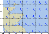 Monday 15/11/04 to Tuesday 16/11/04
Low pressure will become the dominant feature on Monday, giving a strong north-westerly airflow. However, it will be a cold north-westerly this time, coming all the way from Greenland. Scotland, northern England and Northern Ireland will be mostly cloudy with spells of heavy rain, and this will turn to snow over the hills and mountains later. Elsewhere across England and Wales, there will be some brightness, but also plenty of showers, some with hail and thunder. The north-westerly wind will remain strong into Tuesday, and showers across northern areas will become increasingly wintry, with appreciable snowfall over the Scottish Mountains. Even across the higher ground of northern England, Wales and Ireland, showers will turn wintry, with hail and thunder at lower levels. It will feel rather cold everywhere, especially in places exposed to the strong north-westerly wind. Please check back for further forecast updates.