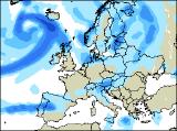
Long-range Outlook: 12/01/05 - 17/01/05
Settled for a time in the south. Rain elsewhere.
Click here for details of the weather over the next few days.
Please note that forecasting beyond five days is notoriously difficult, and small errors at short-range can lead to large deviations further in time. Our longer-range forecasts are based on the most accurate weather data available at the time, but alterations may be required as the period progresses. Please check back regularly for the most up-to-date forecast run.
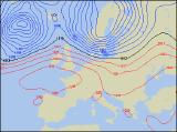
Wednesday 12/01/05 to Thursday 13/01/05
On Wednesday, another deep area of low pressure will roll eastwards to the north of Scotland, bringing a spell of rain to many northern areas of the UK. However, this will clear into the North Sea by midday. Thereafter, winds will turn north-westerly making it feel colder. Heavy showers will blow into Scotland, Northern Ireland and north-west England, with sleet and snow above 200m. However, the rest of England and Wales, together with Ireland will become mostly dry with sunny spells. Models have been signalling a change in the weather across southern parts of the UK for some time now, and this is still looking to be the case. As high pressure builds up from France, much of England, Wales and south-east Ireland will have a dry day with sunny spells. It will become frosty overnight though. For Scotland and Northern Ireland, together with western areas of the Irish Republic, it will be milder and windy with a good deal of cloud giving rain and drizzle later.
 Friday 14/01/05 to Saturday 15/01/05
The fine, settled weather will become confined to the Midlands, central and southern England and south Wales on Friday, as another deep area of low pressure sweeps across northern areas. This will bring strong to gale force south-westerly winds to Northern Ireland and Scotland, together with spells of rain. Ireland and northern England will also have rain at times, although it will be more patchy. On Saturday, a weak band of rain will spread eastwards across all areas during the morning, leaving England and Wales dry and sunny during the afternoon. However, across Scotland and the far north of England, the rain will hang around for longer and will become heavier again later. Northern Ireland and the Irish Republic will have some sunny spells once the early rain has cleared, but western areas will always have a few showers. Towards evening, yet more wind and rain will move in from the north-west.
 Sunday 16/01/05 to Monday 17/01/05
Unsettled weather looks like returning to all parts with a vengeance on Sunday, as winds turn north-westerly. Outbreaks of heavy rain will sweep south-eastwards across all areas, giving several hours of wet weather in places. Once the rain clears away from Ireland, Wales and southern England, it will be replaced with heavy and thundery showers, some with hail. The rain will take longer to clear from Northern Ireland, Scotland and northern England, where there is a risk of gale force winds. The start to next week is looking very similar to the weekend's weather, with north-westerly winds continuing to drag in heavy showers or longer spells of rain. However, there are hints that more settled conditions will gradually edge into south-western areas, although confidence on this is currently very low. As ever, please check back for further forecast updates.