Long-range Outlook: 13/06/05 - 18/06/05
Cloudy & cool East. Sunny & warm West.
Click here for details of the weather over the next few days.
Please note that forecasting beyond five days is notoriously difficult, and small errors at short-range can lead to large deviations further in time. Our longer-range forecasts are based on the most accurate weather data available at the time, but alterations may be required as the period progresses. Please check back regularly for the most up-to-date forecast run.
Monday 13/06/05 to Tuesday 14/06/05
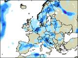
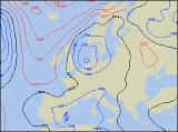
After the sunny and warm spell of this week, the start of night week will be more unsettled. With low pressure over Scandinavia, cool northerly winds will drag a lot of cloud in from the North Sea, especially across eastern Scotland and eastern England. This will be thick enough for showery rain in places, heaviest across East Anglia. The rest of the UK will be drier, with a better chance of some brightness. The best of the sunny spells will be across Ireland and Northern Ireland, but everywhere will feel cooler in the brisk northerly breeze. The won't be a great deal of change on Tuesday, as low pressure to the east keeps us in a northerly flow. A lot of cloud across central and eastern areas will continue to threaten showers from time to time, and along North Sea coasts it will feel very cool indeed. Once again, the cloud will break across west Wales, north-west England and most of Ireland to give some sunny spells, although even here an isolated shower or two cannot be ruled out. Temperatures will range from the mid to high teens Celsius in the west, but struggling to reach double figures in the east.
 Wednesday 15/06/05 to Thursday 16/06/05
The Scandinavian low will gradually weaken and die on Wednesday, but it will still leave a legacy of low cloud across eastern areas, still with the odd spot of drizzle. Elsewhere, as pressure begins to rise, morning cloud will burn off to leave a much brighter day with long spells of sunshine. With much lighter winds, it will feel warmer than over the previous few days, with temperatures returning to the low twenties Celsius across southern Ireland, south-west England and south Wales. Still rather cool along the east coast though. On Thursday, most places can expect a dry day with high pressure building to the west. There will be some sunny spells country-wide, although once again the best of these will still be across Ireland and Northern Ireland. Weather fronts in the North Sea and over the near continent will generally increase the cloud later across eastern parts of England, perhaps with the odd shower towards evening. Feeling pleasantly warm in the sunshine, as winds remain very light.
 Friday 17/06/05 to Saturday 18/06/05
The beginnings of a change are expected on Friday, although details at present are rather uncertain. High pressure centred over the UK will ensure a dry and bright day everywhere, with some sunny spells. Feeling warm too, as winds will be almost non-existent. However, the Atlantic looks to be awakening once again, with low pressure nearing western parts of Ireland. This will bring a good deal of cloud here, threatening rain towards the end of the afternoon. On Saturday, the dry and sunny weather will just about hold on across eastern parts of both England and Scotland. Elsewhere, it will be cloudier with a fresh south-westerly breeze. Outbreaks of showery rain will affect most of Ireland through the day, perhaps nudging into western parts of Wales and Scotland, as well as south-west England. It will remain very mild, or even warm everywhere though. Please check back for further forecast updates.