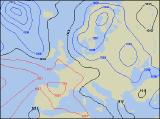
Long-range Outlook: 12/07/04 - 17/07/04
Summer is long overdue, but there's still no sign of it!
Click here for details of the weather over the next few days.
Please note that forecasting beyond five days is notoriously difficult, and small errors at short-range can lead to large deviations further in time. Our longer-range forecasts are based on the most accurate weather data available at the time, but alterations may be required as the period progresses. Please check back regularly for the most up-to-date forecast run.
Monday 12/07/04 to Tuesday 13/07/04
The start of the new week will begin much like the last - unsettled. With brisk north-westerly winds across the UK, temperatures will remain below average everywhere. Showery bursts of rain will affect much of eastern England and eastern Scotland, where it will be rather cloudy. Elsewhere, there will be some sunny spells, especially across Ireland and south-west England, but also a scattering of showers, some heavy. By Tuesday, the north-westerly wind will ease and become westerly, so in the sunny spells across England and Wales it should feel quite pleasant, and it should stay dry here. Across Scotland though, the sharp showers will continue throughout the day, and during the afternoon, thicker cloud across Ireland and Northern Ireland will spread more persistent rain in from the west.
 Wednesday 14/07/04 to Thursday 15/07/04
As indicated in earlier forecasts, a ridge of high pressure still looks set to nudge in across Ireland, Wales and south-west England during Wednesday. This will ensure a mostly dry day with some sunny spells, although it will still be a little cool. The rest of England and Wales will be rather cloudy with outbreaks of rain, some heavy. After a wet start, Scotland and Northern Ireland will brighten up, but blustery showers will blow in, or develop on fresh westerly winds. By Thursday, the ridge will have transferred eastwards to affect much of central southern and south-east England, but it will be weakening all the time. This area should stay dry with sunny spells, but the odd shower cannot be ruled out. Scotland and Northern Ireland will have scattered showers, and later in the day more persistent rain will sweep in from the south-west across Ireland, south-west England and Wales.
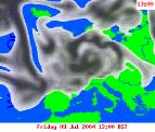 Friday 16/07/04 to Saturday 17/07/04
It looks, at present, like the next deep area of low pressure will swing into the north-west on Friday. With it will come strong south-westerly winds across Northern Ireland, Scotland and northern England, and outbreaks of heavy rain. This rain will sweep eastwards across much of the country during the day, although some eastern parts of England may escape dry and bright until the evening. The low pressure centre will hang around across Scotland on Saturday, giving outbreaks of heavy and persistent rain. Elsewhere, there will be a mixture of sunny spells and blustery showers, some heavy with the risk of hail and thunder. Temperatures will be around average or a little below, so the unseasonably cool, unsettled weather looks like continuing right through next week.