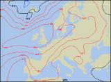
Long-range Outlook: 11/07/05 - 16/07/05
Summer slowly disappearing again!
Click here for details of the weather over the next few days.
Please note that forecasting beyond five days is notoriously difficult, and small errors at short-range can lead to large deviations further in time. Our longer-range forecasts are based on the most accurate weather data available at the time, but alterations may be required as the period progresses. Please check back regularly for the most up-to-date forecast run.
Monday 11/07/05 to Tuesday 12/07/05
By Monday, most of the UK and Ireland will be basking in traditional summer weather, as a large area of high pressure sits right over the country. There may be some low cloud and mist around at first, especially along North Sea coasts of East Anglia and south-east England. Temperatures will be in the mid to high twenties Celsius country-wide, with long spells of sunshine through the afternoon. Winds will be mostly light, although across northern Scotland a fresh south-westerly will develop later. Similarly, south-east England will have a rather cool north-easterly breeze. On Tuesday, high pressure will remain essentially in control, but it will be declining westwards during the day. Most of Ireland and Northern Ireland will be dry with warm spells of sunshine. For England and Wales it will be a similar story, although there will be more cloud around than during Monday. The changes will be taking place across Scotland, as weak weather fronts give rather cloudy skies and occasional rain and drizzle, mostly in northern areas.
 Wednesday 13/07/05 to Thursday 14/07/05
The area of high pressure will slip even further away to the west on Wednesday, but it should stay dry with some sunny spells across Ireland, Wales and central parts of England. Across Northern Ireland and much of Scotland, fresh west to north-westerly winds will pull in a good deal of cloud, with outbreaks of showery rain. Eastern Scotland, in the shelter from the Highlands, should remain dry though. This rain will affect northern England later in the day, and at the same time, fresh north-easterly winds will threaten showers across southern coastal counties of England. By Thursday, only central and southern England and Wales will be holding on to settled, sunny conditions, although there will be a lot of cloud. Elsewhere, north-westerly winds will be strengthening further, as a band of cloud and occasional rain spreads slowly southwards. Ireland may start off dry with some sunshine in the south, but even here it will become damp. Fairly cool everywhere, with temperatures typically below average, except for southern England where it will still be quite warm.
 Friday 15/07/05 to Saturday 16/07/05
Low pressure will start winding itself up across western Scotland on Friday, bringing with it strong south-westerly winds and outbreaks of heavier rain. This rain will affect all of Scotland during the day, spreading southwards acorss Northern Ireland, northern England, and later north Wales. Further south across the rest of England and Wales, there will be some sunshine, but also a scattering of slow-moving showers. Saturday is currently looking cool and unsettled everywhere, as a deep area of low pressure fires north-westerly winds across all areas. The winds could potentially reach gale force for a time along North Sea coasts, and here it will be overcast with heavy spells of rain. The best of any sunshine will be in sheltered parts of south Wales, south-west England and the south of Ireland. However, even here there will be a scattering of showers. Please check back for further forecast updates.