Weekly Outlook : 08/08/03-14/08/03
Staying Hot South-east. Cooler elsewhere over weekend. Coastal Fog.
 Friday 08/08/03 to Saturday 09/08/03
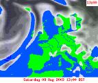
Fog and low cloud greeting many parts on Friday morning, particularly thick nearest to the coast. For southern England, much of Ireland and western Scotland, the sun will shine for much of the morning. This will continue in the afternoon, with many other areas seeing the cloud break to allow sunny spells. Feeling very warm or hot once more, but some eastern coastal regions will be stuck with low cloud and cool temperatures right through the day. Overnight, fog will roll back in with many parts becoming cloudy, and this sets the scene for Saturday morning. Much of England, Wales and Scotland with have another hot, sunny day once mist clears, but once again eastern coasts may remain dull all day. Thicker cloud will spread gradually eastwards across Ireland and Northern Ireland, associated with a cold front. This may bring a scattering of showers, and will reach the Irish Sea by dusk. Turning cooler and fresher behind this, but another muggy, close night elsewhere.
 Sunday 10/08/03 to Monday 11/08/03
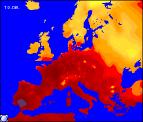
Sunday will see thicker cloud spreading across Scotland, Northern England and other western coastal parts. There is the potential for some showery activity at times, but this mostly scattered. Apart from some east coast mist, England and Wales will have another hot, sunny day with temperatures still in the 30's Celsius. Behind this front, across Ireland and western Scotland, bright with sunny spells but feeling cooler and fresher here, with temps in the low 20's Celsius. Overnight and into Monday, fronts will remain almost stationary in a line from eastern Scotland to south-west England, bringing further cloud and the odd shower. To the east of this line, hot and humid once more with sunny spells. To the east, sunny here too, but fresher although still on the warm side. Little change into the evening and overnight, so another warm, sticky night for England and Wales.
 Tuesday 12/08/03 to Thursday 14/08/03
Slowly but surely during Tuesday and Wednesday, the cold front will drag its heels eastwards across central England, but becoming weaker and fizzling out altogether by Wednesday afternoon. High pressure returning from the south-west will give all parts a sunny couple of days, with cooler fresher air affecting everywhere except the south-east. Wednesday will be warmer than Tuesday however, but the humidity both day and night will be far less than of late. By Thursday, this will begin to build once more however, with temperatures back into the high twenties Celsius in places. As ever, more detail in the next forecast update, although it does look as if the heatwave is here to stay!