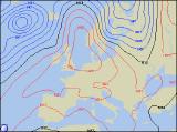
Long-range Outlook: 12/09/05 - 17/09/05
A summery week for many. Rain in north.
Click here for details of the weather over the next few days.
Please note that forecasting beyond five days is notoriously difficult, and small errors at short-range can lead to large deviations further in time. Our longer-range forecasts are based on the most accurate weather data available at the time, but alterations may be required as the period progresses. Please check back regularly for the most up-to-date forecast run.
Monday 12/09/05 to Tuesday 13/09/05
Please note: The addition of ex-hurricanes/tropical storms into the mid-Atlantic next week is resulting in low confidence for long range forecasting at present.
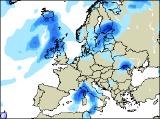
We're expecting a fairly quiet start to next week, as a small nose of high pressure passes gradually over the UK. Sunshine amounts won't be stunning by any standards, but most places will have, at least, some sunny spells. Cloud will be thick enough across northern parts of Scotland for a few showers, and early cloud and drizzle across south-east England could prove reluctant to clear. The best of the sunshine is likely to be across Wales, south-west England and southern parts of Ireland, and here it will be pleasantly warm. On Tuesday, the ridge of high pressure will maintain dry and fairly sunny conditions across a large part of England and Wales. However, the exception will be north-west England, and perhaps the far north-west of Wales, where it will be rather cloudy and damp. Fresh south-westerly winds and a lot of cloud will give periods of rain across Scotland and Ireland, always heaviest and most persistent in western areas. Perhaps the sheltered south-east of Ireland, as well as eastern Scotland, will have occasional brightness.
 Wednesday 14/09/05 to Thursday 15/09/05
There will be very little change on Wednesday, with a large area of high pressure giving settled and sunny conditions across England and Wales. Low pressure to the north-west of the UK will give strong south-westerly winds and further periods of rain across Scotland and Northern Ireland, with potentially heavy bursts likely. Once again though, sheltered by the mountains, eastern Scotland will be drier. The Republic of Ireland will also be drier, away from western coastal areas. Although the high pressure is expected to decline during Thursday, it will still have enough influence to give England and Wales another warm day with sunny spells. An increasingly narrow band of rain will continue to affect Northern Ireland and much of Scotland, although there will still be some heavy bursts here at times. The Irish Republic will start dry and sunny, but rain will edge erratically southwards into northern areas through the afternoon.
 Friday 16/09/05 to Saturday 17/09/05
On Friday, it's currently looking like high pressure will try and build in from all sides. This will effectively kill off the weather fronts across parts of Ireland, Scotland and northern England, leaving behind just a lot of cloud. In the far north of Scotland, it should turn brighter through the day, although there will be an autumnal nip in the air. Further south across the rest of England and Wales, there will be more cloud around, but it should remain dry with some sunny spells. By Saturday, another band of rain will move in from the west across Scotland, with some heavier bursts by evening. This will be the exception to the rule however, as the rest of the UK stays dry with some warm sunshine. Once again, the best of the sunshine will be across Wales and south-west England. A quick look ahead to Sunday sees very little changing, so all in all it should be a decent weekend with some sunshine away from Scotland. For a more detailed look at the weekend of the 17th and 18th September, please check back for further forecast updates.