Long-range Outlook: 13/12/04 - 18/12/04
Turning unsettled with rain. Colder for a time.
Click here for details of the weather over the next few days.
Please note that forecasting beyond five days is notoriously difficult, and small errors at short-range can lead to large deviations further in time. Our longer-range forecasts are based on the most accurate weather data available at the time, but alterations may be required as the period progresses. Please check back regularly for the most up-to-date forecast run.
Monday 13/12/04 to Tuesday 14/12/04
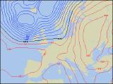
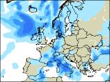
England and Wales can expect a cold, and possibly foggy start to Monday, as high pressure over the near continent remains in control. However, once the morning murk has cleared, it'll stay dry across these areas with some sunshine. Eastern parts of Ireland and eastern Scotland should also stay dry with some brightness. Freshening south-westerly winds will drag thicker cloud and occasional rain across Northern Ireland, western Scotland and western parts of the Irish Republic through the afternoon. By Tuesday, only south-east England will remain generally fine, once morning fog patches have cleared. Elsewhere, the gusty south-westerly winds will have brought milder air from the west, together with plenty of cloud and occasional rain. The rain across England and Wales will be largely light and patchy, but heavier rain will sweep into Northern Ireland and Scotland through the afternoon.
 Wednesday 15/12/04 to Thursday 16/12/04
On Wednesday, the transition to fresher and breezier conditions will be complete, as the last of the rain clears away from eastern England through the morning. However, across Scotland the rain may take much of the day to clear away, with the risk of it turning to sleet and snow over the hills before it does so. Northern Ireland, Ireland, Wales and remaining parts of England will have plenty of sunny spells, but scattered showers will blow in, heaviest and most frequent in the west. A deep area of low pressure to the north of Scotland may give potentially stormy weather on Thursday, although confidence in this is currently low. Winds could reach gale or even severe gale force across Scotland and Northern Ireland, and will be accompanied by several hours of heavy rain. The rest of the UK and Ireland will also cloud over with heavy bursts of rain, after a bright start across southern parts of England.
 Friday 17/12/04 to Saturday 18/12/04
On Friday, as the low pressure pulls away eastwards, a strong northerly wind is expected to blast across most places. Heavy rain or showers across Scotland and Northern Ireland will rapidly turn to sleet or snow, especially over the hills. Wintry precipitation will also spread southwards, across the hills of northern England and north Wales. Later in the day, drier and brighter weather will spread from the west to most of Ireland and Northern Ireland. On Saturday, a transient ridge of high pressure will give most places a cold and frosty morning, but it should stay dry through the day with some sunshine. The exception will be across Northern Ireland and western Scotland, where more weather fronts will bring cloud and rain across these areas by evening. Please check back for further forecast updates.