Long-range Outlook: 14/03/05 - 19/03/05
Milder, but extremely unsettled.
Click here for details of the weather over the next few days.
Please note that forecasting beyond five days is notoriously difficult, and small errors at short-range can lead to large deviations further in time. Our longer-range forecasts are based on the most accurate weather data available at the time, but alterations may be required as the period progresses. Please check back regularly for the most up-to-date forecast run.
Monday 14/03/05 to Tuesday 15/03/05
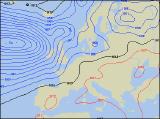
After the lengthy period of wintry weather of late, with temperatures below average for the time of year, Monday will see the start of big changes in our weather. With low pressure steaming in from the south-west, much milder air will begin to pump across the UK and Ireland from the central Atlantic. However, this will result in unsettled weather during Monday, with rain sweeping eastwards across Ireland and Northern Ireland during the day. Across England and Wales, the cloud will steadily increase after a bright morning, with the risk of rain by evening in the west. Scotland will hold on to the cold weather though, with a risk of wintry showers across eastern areas. On Monday night, the rain will continue eastwards across England and Wales, but could cause some problems as it meets the colder air in Scotland into Tuesday morning. This will be in the form of snow, with several hours of heavy snow possible across many areas in Scotland. Elsewhere across England and Wales, heavy rain and possibly some thunder will sweep eastwards in the morning, with more rain by evening.
 Wednesday 16/03/05 to Thursday 17/03/05
On Wednesday, we're expecting a waving weather front to be sat through central parts of Ireland, north Wales, northern England and southern Scotland. This will hardly move through the day, thus some large rainfall totals and localised flooding may be a risk towards evening in these parts. With the cold air still digging in across Scotland, this rain may turn to snow over the Southern Uplands, with some substantial snowfall here. The rest of Scotland will be brighter but with wintry showers. Further south across the rest of England and Wales, it will be much milder, with temperatures pushing the low teens Celsius across southern England, where there'll be the best of any sunny spells. The rain will continue across northern areas during Thursday, exasperating any flooding problems here. However, the rain will also push across all of Scotland, with the milder air finally reaching all parts after initial snow turns back to rain. Across southern England and south Wales, rain will sweep eastwards after a bright morning, with some heavy bursts likely. Staying mild here.
 Friday 18/03/05 to Saturday 19/03/05
Friday is expected to remain mild, but very unsettled indeed. Widespread rain, associated with complex frontal systems will spread east across most places during the day, and as it clears towards evening there is the potential for squally conditions with hail and thunder in places. However, during Friday night, more rain will continue across northern parts of England, southern Scotland and much of Ireland, lasting into Saturday morning. South of this, across the rest of England and Wales, Saturday should be a mostly dry day, with sunny spells and only scattered showers. Elsewhere, the rain looks set to continue, with the heaviest bursts always over coasts and hills in the west. South-westerly winds will be strong in places, with gales around Irish Sea coasts. Please check back for further forecast updates on the weather for next week.