Weekly Outlook : 11/04/03-17/04/03
Dry/sunny at first, rain in south next week. Turning warmer.
 Friday 11/04/03 to Saturday 12/04/03
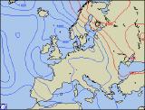
The very gradual change to more unsettled weather will be on hold during Friday, as high pressure holds on by the skin of its teeth! A sunny, but very chilly start for most parts with patchy frost. Thereafter a pleasant day, and with lighter winds in the south it won't feel quite as cold with highs of 10°C-14°C. Fronts will keep the far north-east cloudier, as well as the south-east with the odd light shower. By Saturday, cloud will be thickening across Ireland and across southern England, with patchy light rain later. Elsewhere, another sunny day after a chilly morning with patchy mist and fog. Top temperatures of 12°C-15°C today.
 Sunday 13/04/03 to Monday 14/04/03
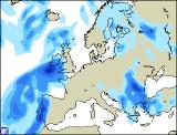
A cloudier start to Sunday across the south, with fronts spreading rain northwards. Most of this light to moderate, but the odd heavier burst as it travels across the higher ground in the south-west and Wales. Staying dry and fine across northern parts, and turning milder everywhere with a strong southerly wind. By Monday, the rain will persist across southern and central parts, perhaps turning heavier as it inches further northwards. A scattering of showers across Scotland and Northern Ireland, but also some sunny spells. Turning very mild, as winds continue from the south or south-east.
 Tuesday 15/04/03 to Thursday 17/04/03
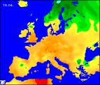
This three-day period is proving tricky to forecast, although it looks likely that temperatures will be on the up! A south to south-easterly flow is the predominant scenario at present, with low pressure close by. Temperatures will reach into the low twenties in any sunshine, although the likelihood of heavy showers, with thundery rain at times looks possible. The best of the weather will be further north, although with confidence low at this time this will be verified in the next update.