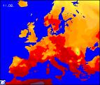
Long-range Outlook: 12/08/04 - 17/08/04
Staying generally warm, but remaining largely unsettled with showers.
Click here for details of the weather over the next few days.
Please note that forecasting beyond five days is notoriously difficult, and small errors at short-range can lead to large deviations further in time. Our longer-range forecasts are based on the most accurate weather data available at the time, but alterations may be required as the period progresses. Please check back regularly for the most up-to-date forecast run.
Thursday 12/08/04 to Friday 13/08/04
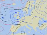
Low pressure, the remnants of hurricane Alex, will continue to dominate the weather across the UK on Thursday, centred right over the country. This will translate into a good deal of cloud, with outbreaks of rain in places. The most persistent rain will be across northern England and southern Scotland, as elsewhere a few sunny spells will develop. However, these sunny spells will trigger heavy, thundery downpours, as it will remain rather warm and humid across the country. There will be little change on Friday, with low pressure sat firmly across the UK. Some places may start off dry with some sunny spells, but the cloud will quickly bubble up to give heavy showers. Some of the showers will turn thundery during the afternoon, and some longer periods of rain are still likely across some central and northern parts. Temperatures will return to near-average levels for the time of year.
 Saturday 14/08/04 Sunday 15/08/04
Although low pressure will be nearby on Saturday, showers will be fewer and further between than of late. There will be rather a lot of cloud around at times, but sunny spells will still break through, particularly across Scotland, northern England and Northern Ireland. The rest of England, Wales and Ireland will be at greatest risk from afternoon showers, although the warmest temperatures will be found here. High pressure looks set to build back in from the south-east on Sunday, giving many central and eastern parts of England and Scotland a mostly fine day, with some sunshine. Out to the west, low pressure will still exert influence, with a good deal of cloud and occasional rain and drizzle spreading reluctantly from the west. Becoming pleasantly warm in the east, but with temperatures around average in the breezier west.
 Monday 16/08/04 Tuesday 17/08/04
The weather for the early part of next week is currently looking warm, but rather unsettled. Low pressure to the west of the UK and high pressure to the east will draw in a run of warm south-westerly winds. However, these will also bring plenty of cloud and outbreaks of rain, heavy at times across Wales, Ireland and south-west England . This situation will last through much of Monday and Tuesday, with the hint of more thundery weather in the south-east beyond Tuesday. Please check back for further forecast updates on next week's weather.