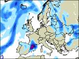
Long-range Outlook: 14/10/05 - 19/10/05
Fine start to weekend. Rain later.
Click here for details of the weather over the next few days.
Please note that forecasting beyond five days is notoriously difficult, and small errors at short-range can lead to large deviations further in time. Our longer-range forecasts are based on the most accurate weather data available at the time, but alterations may be required as the period progresses. Please check back regularly for the most up-to-date forecast run.
Friday 14/10/05 to Saturday 15/10/05
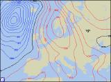
High pressure will dominate the UK's weather on Friday, ensuring a settled day for England and Wales. Sunshine amounts will vary, as mist, fog and low cloud may be slow to clear. Most of Ireland and Northern Ireland will also have a dry day with some sunshine, although cloud will thicken across western areas as the southerly breeze freshens. Eastern Scotland will enjoy and dry day with some sunshine, but there will be more cloud across western Scotland, with drizzle over the Northwest Highlands. Feeling pleasantly warm in the sunshine everywhere, after a chilly start. As high pressure nudges into the North Sea on Saturday, it will encourage a fresh southerly wind across the UK and Ireland. Conditions, as a result, will remain very warm for mid-October, with temperatures possibly reaching 20 Celsius in southern areas. Central and eastern England, together with eastern Scotland, will remain dry with some sunshine. Across the rest of England and Wales, together with western Scotland and most of Ireland, it will be cloudier with patchy drizzle. Strong winds in the west later.
 Sunday 16/10/05 to Monday 17/10/05
By Sunday, any influence of high pressure will become restricted to northeast England and eastern Scotland, where it will remain dry with sunshine. The rest of England and Wales will have a cloudier day, with outbreaks of showery rain developing widely, as a small area of low pressure drifts northwards. At the same time, another weather front will give rain across southern and western parts of Ireland, this spreading to Northern Ireland later. Western Scotland, although starting bright, with turn cloudier with rain. Feeling cooler than recently, although winds will be light. Monday will be a very mixed day across the UK and Ireland, as weather fronts become slow-moving. The heaviest rain and cloudiest skies will be across Ireland and Northern Ireland, with rain at times too in western Scotland. The best of any sunshine will be in eastern Scotland and eastern parts of England once again. In between, across the rest of England and Wales, there will be a mixture of occasional sunshine, but also a lot of low cloud, with drizzle and light rain over the mountains of Wales and northwest England.
 Tuesday 18/10/05 to Wednesday 19/10/05
Due to the nature of slow-moving weather fronts on Tuesday, the forecast currently has low confidence. However, indications are suggesting that fronts will not have moved very far from Monday, giving more rain across Ireland and Northern Ireland. The rain is expected to drift into western Scotland, Wales and western England in the afternoon, but the rest of eastern Scotland and eastern England will remain dry with sunny spells. There will be very little change into Wednesday too, although any heavier bursts of rain across Ireland should slowly give way to lighter rain. There will be some sunny spells across England and Wales, but always with a lot of cloud. Perhaps the best chance of sunny spells will be in eastern Scotland. For more details on next week's weather, please check back for further forecast updates.