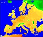
Long-range Outlook: 15/04/04 - 20/04/04
Warmer by the end of this week, but with some heavy rain.
Please click here for details of the weather over the next few days.
Thursday 15/04/04 to Friday 20/04/04
By Thursday, many southern and eastern parts of the UK can expect their first taste of summer, with warm southerly winds spreading across many parts. For much of England and Wales, there will be variable amounts of cloud and sunny spells, with temperatures reaching the mid to high teens Celsius. For much of Ireland together with western Scotland, there will be rather a lot of cloud with showery bursts of sometimes heavy rain, accompanied by fresh to strong south-westerly winds. There will be little change into Friday, with a good deal of cloud persisting across much of Ireland, Northern Ireland and Scotland, still giving sporadic, but often heavy bursts of rain. England and Wales should remain mostly dry once again with sunny spells, and temperatures may reach the low twenties Celsius in south-eastern parts. There is the risk of one or two isolated heavy showers in southern coastal parts during the evening however.
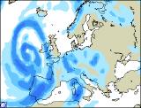
 Saturday 21/04/04 to Sunday 22/04/04
On Saturday, western parts of England and Wales together with much of Ireland and Scotland will have outbreaks of showery rain, some heavy with the risk of thunder. There will also be strong south-westerly winds, reaching gale force in exposed northern parts. For the rest of England and Wales, it will be bright with sunny spells, but also rather warm, and this may trigger a scattering of heavy showers during the late afternoon and into the evening. On Sunday, conditions will become very unsettled across much of the country, with outbreaks of rain spreading from the south and the west. Some of the rain will be heavy, with isolated thunderstorms possible, and it will become cooler from the west during the day. After the heavy rain has cleared, Northern Ireland and Ireland will brighten up for a time, before my wind and rain arrives during the evening.
 Monday 23/04/04 to Tuesday 24/04/04
Everywhere will be cooler on Monday, with a fresh to strong west to south-westerly wind. Heavy showers will develop across many parts during the afternoon, after a mostly dry and sunny start. Some of the showers will be thundery, with the risk of hail, and they will become organised into bands as they cross the country from west to east. Eastern parts of Scotland may have more persistent rain for much of the day, with a keen easterly wind. There may well be a respite from the unsettled conditions across Scotland and Northern Ireland on Tuesday, with predominently dry and bright weather. For the rest of England and Wales however, there will be some sunshine at first, but outbreaks of rain already across Ireland will sweep eastwards during the day, some heavy. As ever, please check back for long-range forecast updates.