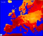
Weekly Outlook : 11/07/03-17/07/03
A Hot Weekend! Thundery Breakdown Next Week!
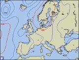
 Friday 11 /07/03 to Saturday 12/07/03
After overnight fronts have cleared south-east England, everywhere will have a much fresher, less humid day. For England, Ireland and Wales, there will be plenty of sunshine interspersed with cloudier spells, with top temperatures in the south of 23C. In western Scotland and Northern Ireland the morning will see some heavy showers around, blown on by stiff westerly winds. Into the afternoon however, these should die away and overnight will become confined to the extreme north-west of Scotland. Into Saturday, high pressure will be re-establishing from the south-west, so for the majority summer will return! Unbroken sunshine for many, with only patchy fair weather cloud around, and top temperatures into the mid twenties Celsius. The exception will be north-west Scotland, where thicker cloud and patchy rain will prove reluctant to clear, but it will improve during the late afternoon.
 Sunday 13/07/03 to Monday 14/07/03
Potentially rather cloudy still in the extreme north-west of Sunday, but elsewhere wall to wall sunshine. The heat will be back on again, with temperatures soaring into the high twenties Celcius in central and southern parts. The humidity will be on the rise once more as winds switch to a southerly direction. Later in the evening, there is the chance of a shower or two in the Channel Isles and Isles of Scilly. Monday will be a hot day, possibly the warmest so far this year with temperatures exceeding 30C in one or two parts. It will be turning less settled despite the heat however, although most northern and eastern parts will stay fine. In the south-west, thunderstorms will break out readily, perhaps developing as far as the Midlands towards evening. Some torrential downpours are likely, but this will not affect temperatures a great deal. Showers will rumble on into the evening and overnight, spreading further north.
 Tuesday 15/07/03 to Thursday 17/07/03
An unsettled day in the west on Tuesday, from Northern Ireland, western parts of Northern England, much of Wales to the south-west. Spells of heavy rain and thunderstorms will develop as the heat builds, some locally torrential downpours with hail. Central and eastern England will have another hot morning, once more reaching 30C in places. During the evening, storms will also break out in central parts, lasting for much of the night. Wednesday will see these downpours transferring to Eastern England, whereas brighter, fresher weather will spread in from the west behind this. Showers remaining in the south-east even into Thursday where it will remain hot and sultry. Elsewhere, cooler, brighter and mainly dry, except in the north-west where showers will blow in from the Atlantic at times.