Long-range Outlook: 13/09/04 - 18/09/04
Unsettled, with heavy rain at times. Very windy with gales.
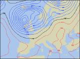
Click here for details of the weather over the next few days.
Please note that forecasting beyond five days is notoriously difficult, and small errors at short-range can lead to large deviations further in time. Our longer-range forecasts are based on the most accurate weather data available at the time, but alterations may be required as the period progresses. Please check back regularly for the most up-to-date forecast run.
Monday 13/09/04 Tuesday 14/09/04
The start of the new week will be very unsettled, with low pressure and weather fronts frequently across the UK. On Monday, one weather front will give cloud and heavy rain across central and eastern England, although this will mostly clear away during the afternoon. Elsewhere, there will be some sunny spells and just a few blustery showers, but these will be heavier and more frequent across parts of Ireland and western Scotland. On Monday night, winds will reach gale, possible severe gale force around northern and western coasts, and this will lead into a stormy start to Tuesday. The strongest of the winds will be across western Scotland, Northern Ireland and north-west England, where they will maintain their strength through much of Tuesday. Most places will see some sunny spells, the best of these in the south. However, there will be a rash of heavy showers, with hail and thunder, and it will be squally during the heaviest downpours.
 Wednesday 15/09/04 Thursday 16/09/04
The entire UK will be in a run of northerly winds by Wednesday, making it feel a lot cooler than recently. There will also be plenty of sunshine, especially across Ireland, south Wales and southern parts of England as a small ridge of high pressure nudges in from the west. However, the showers will return, and these will be heavy and thundery, particularly in Scotland and eastern coastal areas of England. On Thursday, there may be some dry and bright weather initially in eastern parts of the UK. However, a large area of low pressure will be winding up in the Atlantic, and this will thrust active weather fronts eastwards across all parts during Thursday afternoon. Some of the rain will be heavy enough to produce localized flooding, and together with a strong to gale force south-westerly wind, it will feel rather cool. The wettest and windiest conditions will be in the north and west, with lighter rain further south and east.
 Friday 17/09/04 & The Weekend
Thursday's area of low pressure won't have moved very far by Friday, so all parts will remain in a strong south-westerly airflow. Persistent and heavy rain will remain across Scotland and Northern Ireland, although the rest of Ireland, England and Wales will have some brightness between the blustery showers. The low will transfer eastwards on Saturday, taking the heaviest rain into the North Sea. However, although there will be some brightness around, there will still be a good deal of cloud and showery bursts of rain in places. There is a glimmer of hope for settled conditions on Sunday, particularly in southern parts where it should become dry and sunny. Further showers will still affect northern and western parts however, and it will stay rather windy here. As ever, please check back for further forecast updates.