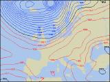
Long-range Outlook: 15/01/05 - 20/01/05
Best sunshine in south. Wintry later next week.
Click here for details of the weather over the next few days.
Please note that forecasting beyond five days is notoriously difficult, and small errors at short-range can lead to large deviations further in time. Our longer-range forecasts are based on the most accurate weather data available at the time, but alterations may be required as the period progresses. Please check back regularly for the most up-to-date forecast run.
Saturday 15/01/05 to Sunday 16/01/05
The influence of high pressure will become restricted to eastern England during Sunday, as low pressure in the Atlantic gets ever-closer. South-east England, East Anglia and Yorkshire will have a mostly dry day with some brightness. However, it will be mostly cloudy elsewhere, with outbreaks of showery rain spreading north-eastwards. After a short drier period, more rain will spread across Ireland into western Scotland and Wales, and this will be heavier at times. During Sunday, this heavier rain will spread to all but south-east England, although it will become light and fragmented in southern areas. Scotland, Wales and northern England will become dry with some brightness during the afternoon, although more wind and rain will spread across Ireland and Northern Ireland towards evening.
 Monday 17/01/05 to Tuesday 18/01/05
Winds will become westerly on Monday, and most areas will become chillier as a result. There will be a lot of cloud across southern and eastern areas, but apart from the odd spot of rain, it will be mostly dry. Over other western areas however, the cloud will be thick enough to give outbreaks of rain. Across western Scotland and Northern Ireland, some of this rain will be heavy, and it will turn to snow above about 350m. Westerly winds could reach gale force here later. On Tuesday, a deep area of low pressure will sweep across northern Scotland, bringing gale force winds and outbreaks of heavy rain. This rain will also spread across Ireland during the morning, reaching northern England, Wales and the north Midlands during the latter part of the afternoon. South-eastern parts of England should stay dry with sunny spells, although the sunshine will become increasingly hazy through the afternoon.
 Wednesday 19/01/05 to Thursday 20/01/05
Cold west to north-westerly winds will affect all areas during Wednesday, once any early rain has cleared away from south-east England. These winds will reach gale force across western Scotland and Northern Ireland, bringing with them a rash of wintry showers. Blizzards will develop over the Scottish mountains, with snow falling to increasingly low levels through the day. A few rain or hail showers will affect western parts of England, Wales and Ireland, but for the most part it will become dry with some sunshine. Thursday is currently looking very unsettled with plenty of cloud and heavy rain across the south. In the north, this rain is expected to turn to sleet and snow, with significant accumulations possible across Scotland and Northern Ireland. However, confidence surrounding this wintry spell is rather low at the moment, so please check back for further forecast updates.