Weekly Outlook : 12/05/03-18/05/03
Showery at first. Dry, chilly for a time. More rain later.
 Monday 12/04/03 to Tuesday 13/05/03
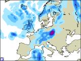
Low pressure dominating the weather on Monday, with rain or showers in most places. The far south of England will see rather a lot of cloud, with showery rain from time to time, some heavy. For the rest of Ireland and the UK, there will be sunny spells but also heavy, blustery showers, most frequent across western Scotland and Northern Ireland. Winds here may touch gale force around the heaviest showers making it feel chilly, but temperatures around average elsewhere. Overnight, cloud and rain will clear the south-east, but more will spread into north-west Scotland. Turning mostly dry elsewhere and quite chilly in places. Into Tuesday, winds will strengthen further across the north-west, swinging round to a more northerly direction by the end of the day. These will drive heavy showers across most parts, some with hail and thunder, wintry over hills in Scotland. The far south and east may just escape dry and sunny. Turning cold in the north, mild in the south.
 Wednesday 14/05/03 to Thursday 15/05/03
The strong northerly flow gradually receding from the west as a ridge of high pressure moves in . However, Scotland and eastern parts of England will see widespread showers pushing south on the northerly winds, some with hail and turning wintry on high ground. Sunny spells increasing out to the west, and most other parts becoming dry by the end of the day. Rather chilly in most parts, and a touch of front likely overnight under clear skies. Thursday will see the reverse situation to Wednesday, as high pressure influences the weather across eastern parts. Sunny spells here, and only the odd isolated light shower in the morning. Out to the west and south-west, fronts will gradually encroach from the Atlantic, bringing rain to south-west Ireland and south-west England by midday. The rain will only reach south Wales and Northern Ireland by the end of the day, but after a brief chillier spell temperatures will start to recover to average values.
 Friday 16/05/03 to Sunday 18/05/03
Very unsettled on Friday, with fronts straddled across central parts. These will produce widespread rain, always heaviest in the west, patchy in the east. The south and west turning bright with showers later, but winds will be very strong in most parts, touching gale force southerly across Northern England and Scotland. The weekend's weather will be dictated by the progress of these weather fronts, which is at the moment, rather uncertain. They are expected to move further north and east, lingering across Scotland well into Sunday. Behind this, a mixture of sunny spells and scattered, heavy showers, but it will turn warm in the south. Towards the tail-end of the weekend, a new area of low pressure looks set to move into the south-west, but confidence at this point is still rather low.