Long-range Outlook: 18/04/05 - 23/04/05
Rain at first. Increasingly sunny later next week.
Click here for details of the weather over the next few days.
Please note that forecasting beyond five days is notoriously difficult, and small errors at short-range can lead to large deviations further in time. Our longer-range forecasts are based on the most accurate weather data available at the time, but alterations may be required as the period progresses. Please check back regularly for the most up-to-date forecast run.
Monday 18/04/05 to Tuesday 19/04/05
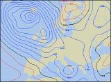
The start to the new week will be unsettled across most of the UK, with a large depression dominating to the west of Ireland. Central and eastern parts of England may start off dry with some sunshine, but showers across Wales and western England will soon spread eastwards, some heavy. Across Ireland and Northern Ireland, longer spells of rain will move in from the west, accompanied by strong westerly winds, perhaps with gales around the coast. Persistent rain will also affect parts of eastern Scotland for much of the day, whilst western Scotland has a mixture of sunshine and showers. Temperatures around average country-wide. Low pressure is expected to sit slap-bang on top of the UK by Tuesday, continuing the unsettled theme. Heavy showers will be widespread across all parts, with a spell of more persistent rain sweeping across England during the morning. During some of the heavier showers, hail and thunder is likely, and the showers will be particularly slow-moving across Scotland. The best of the sunny spells will be across southern and western Ireland, together with south-west England.
 Wednesday 20/04/05 to Thursday 21/04/05
As low pressure pulls eastwards into the North Sea during Wednesday, a northerly flow will develop across most of the country. This will lead to a much chillier day, especially in the north where ground frost is possible during the morning. Showers will break out once again across north-east England, the Midlands, East Anglia and south-east England, with a risk of thunder in the afternoon. However, the rest of England, Wales and Ireland should stay mainly dry with some decent sunny spells. During Thursday, the east-west split is likely to continue. Northerly winds will drag a lot of cloud across eastern England and eastern Scotland, with showery rain for much of the day. Across western England, Wales and western Scotland it should stay dry with some brightness developing. With high pressure building in from the west, the best of the sunshine will be across Ireland and Northern Ireland, and with light winds here it will feel pleasantly warm in the afternoon.
 Friday 22/04/05 to Saturday 23/04/05
Although confidence is currently rather low, it is looking increasingly likely that high pressure will dominate the weather right across the UK and Ireland on Friday. It could well be chilly to begin with, especially in northern areas. However, by afternoon everywhere will enjoy patchy cloud and long spells of sunshine. With generally light winds, it will feel quite warm, although a nagging easterly wind will continue through the English Channel. Very little change is expected by Saturday, with generally sunny skies once morning mist and fog have cleared. The easterly wind in southern areas should disappear too, so it'll feel warmer here. The exception will be north-west Scotland, where increasing south-west winds will drag in low cloud and drizzle towards the end of the afternoon. As ever, please check back for further forecast updates.