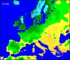
Long-range Outlook: 18/05/05 - 23/05/05
Staying rather cool with rain at times.
Click here for details of the weather over the next few days.
Please note that forecasting beyond five days is notoriously difficult, and small errors at short-range can lead to large deviations further in time. Our longer-range forecasts are based on the most accurate weather data available at the time, but alterations may be required as the period progresses. Please check back regularly for the most up-to-date forecast run.
Wednesday 18/05/05 to Thursday 19/05/05
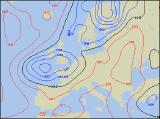
Wednesday's synoptic setup is looking rather complicted, with several areas of high and low pressure all vying to influence the UK's weather. There will be some low cloud and light rain around, most likely in parts of Scotland and eastern England. The rest of England and Wales will be brighter with some sunny spells, although a few showers are possible. Ireland and Northern Ireland may well start dry and bright, but western areas will become cloudier with rain spreading eastwards later. The weather situation will remain rather messy into Thusday, and although winds will be light, a slight northerly drift will make it feel rather cool everywhere. Rain will affect Ireland during the morning, gradually becoming confined to southern parts of England and Wales in the afternoon, but dying away at the same time. The rest of England, Wales and western Scotland will have sunny spells and sporadic, light showers, whilst eastern Scotland and north-east England will stay rather misty with occasional drizzle.
 Friday 20/05/05 to Saturday 21/05/05
On Friday, low pressure will develop more readily to the west of the UK, with south-westerly winds increasing across Ireland, Wales and south-west England through the day. Some heavy bursts of rain will spread north-eastwards across these areas during the afternoon, but it will start to feel milder than of late. To the east of this rain band, there should be some bright or sunny spells. However, northern and eastern Scotland, together with north-east England, will be rather cloudy and cool with a risk of scattered light showers. Very unsettled on Saturday, with a large depression dominating our weather. England and Wales will be mostly cloudy with outbreaks of heavy and persistent rain, the worst of this in southern areas. However, western fringes will become brighter with a few showers later. Rain will also affect Scotland, but this will be more showery and should mostly die away later. The best of Saturday's weather will be across Ireland and Northern Ireland, where there will be a mixture of sunny spells and just a few showers. Becoming colder again as the wind swings in from the north.
 Sunday 22/05/05 to Monday 23/05/05
Models are suggesting that a struggle between high pressure in the Atlantic, and low pressure in the North Sea will commence on Sunday. Unfortunately, this situation always drags cold northerly winds across the UK and Ireland, with their origin in the Arctic. Most of Scotland and eastern England will have a cloudy, rather raw day with outbreaks of showery rain. This will turn to snow over the Scottish Highlands. Elsewhere, there will be some sunny spells, but also plenty of showers. Western parts of Ireland should become drier through the day though. Details are rather uncertain for Monday, and will remain so until nearer the time. However, it is looking likely that most of England, Wales and Scotland will become drier through the day, with some sunny spells. Ireland and Northern Ireland can expect more wind and rain, after a relatively sunny morning. For more details on the weather beyond next week, please check back for further forecast updates.