Long-range Outlook: 18/06/05 - 23/06/05
A humid, thundery weekend. Fine early next week.
Click here for details of the weather over the next few days.
Please note that forecasting beyond five days is notoriously difficult, and small errors at short-range can lead to large deviations further in time. Our longer-range forecasts are based on the most accurate weather data available at the time, but alterations may be required as the period progresses. Please check back regularly for the most up-to-date forecast run.
Saturday 18/06/05 to Sunday 19/06/05
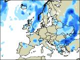
Saturday will be a real day of contrasts across the UK. Central and southern England will be mostly dry with hazy spells of sunshine. It will be very warm and humid, especially in the south-east, and highs across England will range between 25 and 28 Celsius. Ireland, Wales and northern England should also be mainly dry, but as the afternoon wears on there will be an increasing risk of scattered thunderstorms. A very different day for Northern Ireland and most of Scotland, with cloudy skies and showery rain. Some of the rain could be heavy with thunder, and it will turn cooler and fresher. Saturday night could see a display of nature's fireworks, as thunder and lightning gradually accompanies heavy bursts of rain across the Irish Sea into Wales and western parts of England. By Sunday, heavy showers will continue east across the rest of England, and on encountering the hot and humid air in the east during the afternoon, some potentially lively thunderstorms are possible. The rest of the UK and Ireland will be much cooler and fresher on Sunday, with sunny spells and just a few showers.
 Monday 20/06/05 to Tuesday 21/06/05
High pressure will start to build in from the west on Monday, so for much of the UK and Ireland, it'll be a fine, sunny day. With winds swinging around from the north-westerly direction, it'll be much cooler than during the weekend, but in the sunshine it will still be pleasant enough.The best of the sunshine will be across Ireland, Wales and south-west England, and the winds will be lighest here too. The exception to the fine conditions will be northern Scotland, where thicker cloud could threaten the odd spot of drizzle. The anticyclone will be slap-bang across the UK by Tuesday, translating into a glorious day for most of the UK and Ireland. The heat of the afternoon will allow cloud to bubble up, but apart from an isolated light shower or two, everywhere will be dry. Once again, the exception to the rule will be northern Scotland, where there will be an increasing risk of rain and drizzle. Rather cool in the north, with maximum temperatures not any higher than 16 or 17 Celsius, but in the south, 22-25 Celsius seems likely.
 Wednesday 22/06/05 to Thursday 23/06/05
The middle of the week, leading towards the weekend is rather uncertain at this range, but it does look like the fine weather will increasingly be shunted southwards as low pressure deepens to the north of the UK. Cloud and rain is likely to affect most of Scotland on Wednesday, sinking southwards into Northern Ireland and the north of northern England later. The rest of England, Wales and Ireland will have another fine day with lots of warm sunshine. Becoming windy in the north as the day progresses. By Thursday, the sunny skies will be reserved for the far south of England, as cloudier and cooler weather affects the rest of the UK and Ireland. It will still be raining across Scotland, northern England and Northern Ireland, and also across parts of Ireland, but the rain will become increasingly light and patchy as high pressure begins to build once more. As ever, please check back for further forecast updates on next week's weather.