Long-range Outlook: 19/02/05 - 24/02/05
Potentially much colder with a risk of snow.
Click here for details of the weather over the next few days.
Please note that forecasting beyond five days is notoriously difficult, and small errors at short-range can lead to large deviations further in time. Our longer-range forecasts are based on the most accurate weather data available at the time, but alterations may be required as the period progresses. Please check back regularly for the most up-to-date forecast run.
Saturday 19/02/05 to Sunday 20/02/05
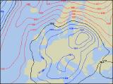
Previous forecasts indicated that the weekend could become much colder once again, and this remains the case. On Saturday, with high pressure out to the west of Ireland, and low pressure over Scandinavia, all parts will be in a cold northerly flow. Northerly winds could reach gale force along North Sea coasts, and heavy showers will affect much of Scotland and eastern England, turning increasingly to sleet and snow in the north, with sleet further south. The best of the drier, brighter weather will be across western areas, as well as much of Ireland. After an overnight frost, Sunday will start dry and sunny in many areas. However, wintry showers across eastern parts will quickly become more frequent, with sleet and snow even penetrating as far south as East Anglia. Blizzards are likely over the Scottish mountains as winds reach gale force. With the strength of the sun at this time of year, a few wintry showers may even break out further west.
 Monday 21/02/05 to Tuesday 22/02/05
With winds remaining north or north-easterly on Monday, it will still be cold across most of the UK and Ireland. Wintry showers will continue in eastern Scotland and eastern England through the day, again with sleet and snow in places.Western England and Wales will be mostly dry with some sunny spells. After a bright morning, thicker cloud will bring patchy rain in from the west across Ireland and Northern Ireland during the afternoon. On Tuesday, it looks as if winds are likely to turn easterly across northern parts of the country, resulting in another cold day with snow showers in eastern areas. At the same time thicker cloud across Northern Ireland, Ireland and western Scotland will give a mixture of rain, sleet and snow. Across eastern England, there will still be some light snow showers around, but elsewhere it will be dry. There will be more cloud around than of late though, so any sunny spells will be fairly limited.
 Wednesday 23/02/05 to Thursday 24/02/05
Wednesday's synoptic setup is currently looking very complicated, and there is low confidence surrounding the weather this will translate into. Winds will be very light everywhere, but it will still remain rather cold. With a good deal of cloud, showers will break out almost anywhere. Although these will be predominantly of rain, snow cannot be ruled out, especially over the highest ground. More persistent and heavy rain will swing into western parts of Ireland during the day. Thursday will be another day of rather cloudy skies and occasional showers. However, later in the day there could be a threat of more persistent rain spreading up from the south. As this hits the colder air acorss the Midlands and southern England, there is the potential for snow. As ever, please check back for updated forecasts of the complex weather situation for next week.