Long-range Outlook: 20/11/04 - 25/11/04
Becoming fine at first. Wet and windy later.
Click here for details of the weather over the next few days.
Please note that forecasting beyond five days is notoriously difficult, and small errors at short-range can lead to large deviations further in time. Our longer-range forecasts are based on the most accurate weather data available at the time, but alterations may be required as the period progresses. Please check back regularly for the most up-to-date forecast run.
Saturday 20/11/04 to Sunday 21/11/04
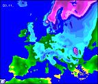
On Saturday, eastern parts of the UK will be in the grip of the forecast cold spell, whereas western areas will become progressively milder. Sunny spells and wintry showers will affect eastern Scotland and eastern England, falling as snow even at low levels in the north, but mostly on the hills in the south. Central and north-west England will be mostly dry but it'll cloud over after a frosty start. Out to the west, Ireland and Northern Ireland will be wet with some heavy rain around, and this may turn briefly to sleet or wet snow over the highest hills of Wales and the west Midlands. By Sunday, the cold northerly winds will have been replaced by milder south-westerly winds across the whole country. Most places will see outbreaks of rain during the day, some heavy, and this will again fall as snow for a time over north-east England and eastern Scotland. As the rain clears western parts of Ireland, it will become brighter but with scattered showers.
 Monday 22/11/04 toTuesday 23/11/04
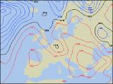
During Monday, a ridge of high pressure is expected to build in from the west across Ireland during the day. As a result, it will become largely dry here with some sunny spells, although it could turn chilly overnight. Western Scotland, Wales and south-west England may start showery, but conditions will dry up here too in the afternoon. Thicker cloud and patchy rain will hang on across eastern Scotland, along with northern and eastern England for much of the day. By Tuesday, high pressure will have moved in, sitting right over southern areas of the UK. After a frosty start, the majority of England and Wales will have a fine day with some sunny spells. Scotland, Ireland and Northern Ireland will also be largely fine, but there will be more cloud around. The cloud may be thick enough in the extreme west of Ireland for patchy drizzle by evening. Another cold and frosty night to follow for many.
 Wednesday 24/11/04 to Thuersday 25/11/04
On Wednesday, England and Wales will still benefit from the influence of high pressure, with bright conditions after a chilly start. As south-westerly winds increase, there will be a lot more cloud across Ireland, Northern Ireland and Scotland, with much milder air rotating around the top of the high. Most places will remain dry, but the far west and north-west of Ireland, together with the Western Isles and north-west Scotland will have periods of quite heavy rain.By Thursday, the settled conditions will be hanging on by the skin of their teeth across southern parts of England. Elsewhere, westerly winds will take over, throwing cloud and rain across most of the country. This will always be heaviest and more persistent across Northern Ireland and western Scotland. Please check back for further forecas updates.