Weekly Outlook : 17/05/03-23/05/03
Numerous Low Pressure Systems : Rain & Showers
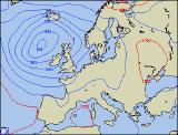 Saturday 17/05/03 to Sunday 18/05/03
A very unsettled weekend in prospect, with bands of rain spreading across the country. Saturday will start with cloudy skies for most, with outbreaks of rain initially across Scotland. Behind this, drier and brighter for a time, but another weather front across the south-west from the offset will spread north-east. Some of the rain will be heavy, reaching northern and eastern England by mid-afternoon. Behind this, turning somewhat brighter, but with scattered blustery showers in strong westerly winds. Scotland and Northern Ireland turning very wet overnight with heavy, persistent rain but becoming mostly dry elsewhere. Into Sunday, rain will clear the Northern Isles and many places will have a bright morning. Bands of heavy showers will spread from the south-west during the day, with cloudier skies and more persistent rain in the south and west later. Generally rather mild for most, but tempered in strong, possibly gale force winds in the south later.
 Monday 19/05/03 to Tuesday 20/05/03
Cloud and rain clearing from the south-east first thing, then brighter across most of England and Wales for a time. Across north-east Scotland, mainly cloudy with scattered showers. Much of Ireland and later western mainland coasts will be cloudy also with spells of rain from time to time. Into the afternoon, showers will develop across central and southern parts, while the rain across the Irish Sea will migrate across Northern England and Scotland. Strong westerly winds continuing, but these slowly moderating into Tuesday as a weak ridge moves in from the west. This will allow central and western parts to have a dry and bright morning. Showers will break out widely in the east however by lunchtime, although dying out again in the afternoon. Out to the west, fronts will bring thicker cloud and patchy rain by the end of the day, as a new area of low pressure develops to the west of the UK.
Wednesday 21/05/03 to Friday 23/05/03
A generally unsettled end to the week, beginning in earnest on Wednesday as cloud and rain sweeps from west to east. Some of this rain will be heavy, with strong winds likely, possibly gale force around exposed western coasts. These weather fronts will be followed by sunny spells and blustery showers, dying out overnight but developing again into Thursday. The most frequent showers will be in the north-west, whereas south-eastern parts may escape with a dry day. A great deal of uncertainty surrounds the current forecast for Friday, however it does look like conditions may begin to settle down. Temperatures will increase across southern parts as high pressure builds from the west. Further details in the next weekly update.