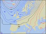
Long-range Outlook: 21/10/05 - 26/10/05
Cold weekend. Mild but wet next week.
Click here for details of the weather over the next few days.
Please note that forecasting beyond five days is notoriously difficult, and small errors at short-range can lead to large deviations further in time. Our longer-range forecasts are based on the most accurate weather data available at the time, but alterations may be required as the period progresses. Please check back regularly for the most up-to-date forecast run.
Friday 21/10/05 to Saturday 22/10/05
An unsettled and wet Friday is expected across England and Wales, as outbreaks of rain spread slowly south-eastwards through the afternoon. Some sunny spells will follow the rain later. Across Ireland and Northern Ireland, there will be a few showers around, perhaps prolonged in the north, but also some sunshine in between the showers. More persistent rain will return to Scotland after a drier interlude, with some heavy bursts likely in the north towards evening. Winds will be generally light, although with a brisk south-westerly across southern England during Friday morning. On Saturday morning, outbreaks of rain will spread slowly south across Scotland, reaching northern England and Northern Ireland in the afternoon. Behind the rain across Scotland, it will turn brighter with some sunshine, but it will also be a good deal colder. A scattering of showers around northern and eastern coasts will turn wintry over the mountains later. England, Wales and the rest of Ireland will be mild through the day, but overcast with showery outbreaks of rain. Fresh northerly winds in most places. A frosty night in the north.
 Sunday 23/10/05 to Monday 24/10/05
A cold a frosty start to Sunday is expected across Scotland and Northern Ireland, and perhaps northern England and north Wales too. However, it will be bright with some sunny spells throughout the day. A scattering of showers will continue to blow in on the brisk northerly wind across northern and eastern Scotland, and again these will fall as snow over the hills and mountains before dying out later. Across the rest of England and Wales, morning rain will clear south, leaving a much brighter afternoon with sunshine. However, it will be much colder, and a few showers will affect eastern coastal areas. Eastern parts of England and Scotland will have another chilly start on Monday, perhaps with an early frost in places. However, a large area of low pressure will develop to the west of Ireland, spreading cloud and rain across most of Ireland, Wales and western England through the morning. During the afternoon, this rain will reach all areas, heavy in places. South-westerly winds will become fresh to strong everywhere, but as a result it will become much milder across the UK and Ireland.
 Tuesday 25/10/05 to Wednesday 26/10/05
We're expecting the Atlantic to be dominated by low pressure on Tuesday, with a strong south-westerly flow giving very mild conditions across the UK and Ireland. There will be some sunny spells first thing across central and southern England, but otherwise most places will have a wet day. Some heavy bursts of rain are likely, especially across Northern Ireland and western Scotland during the afternoon. South-west winds will reach gale force around western Scotland too, as well as Irish Sea coasts later. There will be very little change into Wednesday, with more cloud and rain across Ireland, Northern Ireland and Scotland. Northern England and Wales will also be mostly cloudy with patchy light rain, and it will be rather windy here too. The best of the weather will be across central, southern and eastern England, where it will be dry with occasional sunny spells. For more details of the weather for next week, please check back for further forecast updates.