Weekly Outlook : 17/12/03-23/12/03
Cold & frosty, becoming even colder with the risk of snow.
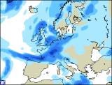
 Wednesday 17/12/03 to Thursday 18/12/03
On Wednesday, England and Wales will have a cold, crisp start with widespread frost and patchy fog. These will quickly clear though, and everywhere can then look forward to a glorious day with plenty of sunshine. A different story for Ireland and Northern Ireland, with rather a lot of cloud and the odd spot of rain in the west. Eastern parts may have a few brighter spells though. Scotland will be rather cloudy, with patchy rain in the far north-west. Milder here, with no problems with frost overnight, but England and Wales will see temperatures plummet with another hard frost and patchy fog. On Thursday morning, this fog and frost will be pretty slow to clear in places but when it does it'll be another bright, sunny day. Ireland will also have a rather brighter day, but cloud will thicken across Northern Ireland, together with Scotland in the afternoon. More persistent, heavy rain is expected here, spreading slowly southwards to reach southern Scotland by dusk. Mild in the north and west, chilly elsewhere.
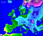
 Friday 19/12/03 to Saturday 20/12/03
Friday will be a much more unsettled day, with a band of rain, often heavy spreading slowly southwards from southern Scotland into parts of Northern England and North Wales by the end of the day. Southern parts of England, Wales and Ireland will also have rather more cloud around, with patchy light rain along the south coast after an early frost. Scotland and Northern Ireland will become a little brighter in the afternoon, but still with scattered showers. Overnight, northern parts will become wet once again, with any frost limited to parts of East Anglia and the south-east. On Saturday, an area of heavy rain will sweep southwards, reaching all parts by the end of the day. Some of this rain will turn to snow over the high ground of Northern England and Wales before clearing. Scotland and Northern Ireland will become brighter but much colder with strong northerly winds and scattered wintry showers.
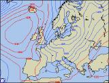
 Sunday 21/12/03 to Tuesday 23/12/03
The first real blast of winter is expected to sweep across all parts on Sunday. Although mostly bright with plenty of sunny spells, there will also be a number of heavy, blustery showers, many of hail, sleet and snow. Most of the showers will be along northern and eastern coasts, wintry even to low levels in south-east England. Gale force northerly winds will make it feel bitterly cold, although western parts should stay dry. On Monday, eastern parts will stay cold with further snow showers and strong northerly winds. Central and western parts will become increasingly drier and brighter as high pressure builds from the west. Tuesday will be mostly dry with sunny spells after an overnight frost, although the odd shower in northern and eastern parts still can't be ruled out. At the moment, this cold weather doesn't look like lasting until Christmas, so a Green Christmas is currently on the cards. However, this is still some time off, and the forecast may change, so more details on the Christmas period will be in the next forecast update.