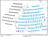
Long-range Outlook: 23/02/05 - 28/02/05
Winter returns with a vengeance!
Click here for details of the weather over the next few days.
Please note that forecasting beyond five days is notoriously difficult, and small errors at short-range can lead to large deviations further in time. Our longer-range forecasts are based on the most accurate weather data available at the time, but alterations may be required as the period progresses. Please check back regularly for the most up-to-date forecast run.
Wednesday 23/02/05 to Thursday 24/02/05
By the time we reach Wednesday of next week, many places in the UK will have already seen freezing overnight temperatures and snow showers. There will be no let up in the cold weather on Wednesday either, with cold easterly winds continuing. After a frosty start across Ireland, much of Wales and western parts of Scotland and England, it will be dry with sunny spells. However, further snow showers will affect eastern England and Scotland, giving a further covering in places. Feeling bitterly cold, especially in the wind with daytime temperatures barely above freezing in places. On Thursday, many northern and western areas will be dry with long spells of sunshine, bar a few wintry showers in eastern Scotland. During the day, thicker cloud is expected to move across southern England and south Wales, giving the risk of sleet and snow in places, although it may fall as rain along the south coast. Remaining parts of England and Wales will be dry with only occasional snow showers. Easterly winds will continue to blow, making it feel rather cold.
 Friday 25/02/05 to Saturday 26/02/05
On Friday, the cold conditions will continue right across the UK, with easterly winds continuing to bring dry, continental air to many areas. After a severe frost, most of Scotland, Ireland and Northern Ireland will be dry with some sunny spells. Wintry showers in southern and eastern England will also become few and far between during the day. Elsewhere across England and Wales, it will be largely dry, although the frost won't lift in some areas for much of the day. There will be little change on Saturday, as high pressure to the north of Scotland draws in cold easterly winds. Sleet and snow showers are likely to make a reappearance across south-eastern parts of England, and will drift through the Channel during the day. The rest of England and Wales will stay mostly dry, with sunny spells and only the outside chance of a wintry shower. Another hard frost will set in during Saturday night.
 Sunday 27/02/05 to Monday 28/02/05
Subtle changes are expected on Sunday, as winds swing round to a more south-easterly direction during the day. There will still be a scattering of sleet and snow showers acorss southern and eastern parts of England, perhaps even on eastern coasts of Ireland. Otherwise it will be mostly dry across the rest of the UK, with some bright or sunny spells, but always a lot of cloud around too. By Monday, we're expecting the winds to swing around to a more southerly direction, which will take away most of the snow showers which will have blanketed eastern areas for most of the previous week. However, there will still be a few rain or sleet showers in southern and western areas. Dry elsewhere with some sunshine, and it will begin to feel slightly less cold. This cold spell looks set to be one of the most severe for several years across the UK, particularly so in eastern areas. For that reason, please check back for further forecast updates on next week's weather.