Long-range Outlook: 21/05/05 - 26/05/05
No sign of summer. Cool with showers.
Click here for details of the weather over the next few days.
Please note that forecasting beyond five days is notoriously difficult, and small errors at short-range can lead to large deviations further in time. Our longer-range forecasts are based on the most accurate weather data available at the time, but alterations may be required as the period progresses. Please check back regularly for the most up-to-date forecast run.
Saturday 21/05/05 to Sunday 22/05/05
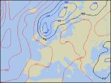
The synoptic situation on Saturday would be more suited to Autumn than late spring, as a deep area of low pressure stretches from Ireland across into Scotland. To the south of this across England and Wales, it will be milder than of late with fresh south-westerly winds. However, early sunny spells will soon trigger plenty of heavy showers across England and Wales, with skies turning mostly cloudy in the afternoon. Across Ireland, Northern Ireland and Scotland, winds will be lighter, but showers will be more frequent. Some of the showers will be heavy, merging to give prolonged rain with low cloud over the hills. On Sunday, the low will gradually drift eastwards, allowing a strong northerly wind to set in across Ireland and Northern Ireland. As a result, skies will be brighter here with only scattered showers, but it will feel colder once again. For England and Wales, winds will remain westerly with a mixture of sunshine and heavy downpours. More prolonged rain will continue to plague Scotland, although western areas will turn colder and brighter through the afternoon.
 Monday 23/05/05 to Tuesday 24/05/05
The new week will begin as the last ended; unsettled. Low pressure will continue to dominate to the north of Scotland on Monday, with most of the UK and Ireland in a brisk west to north-westerly airflow. Temperatures will be at, or below average everywhere, and it will feel unpleasant in the wind. Any persistent rain will be reserved for Scotland and north-east England, where some will be heavy. The rest of England and Wales, together with Ireland and Northern Ireland will have a mixture of sunny spells, but also increasing numbers of showers. Some of the showers will be heavy with thunder, and a risk of hail in places too. Tuesday will see very little change in our weather, with the showery, cool weather regime continuing. The best of the sunshine will be in southern parts of Ireland, as well as south Wales and southern England. A few showers will crop up here in the afternoon, but many areas will remain dry. A different story for the rest of England, Northern Ireland and Scotland, with plenty of cloud and heavy showers merging to give prolonged rain. Chilly in the brisk wind.
 Wednesday 25/05/05 to Thursday 26/05/05
The low pressure parked to the north-east of Scotland through the week will begin to fill during Wednesday. As a result, the chilly north-westerly wind will be lighter for many, making it feel more pleasant in the sunny spells. However, the morning sunshine will soon trigger scattered showers almost anywhere. During the afternoon, a few rumbles of thunder are likely, and some of the showers could give localised downpours. However, the best chance of staying dry will once again be across southern parts of Ireland and south-east England. Very little change is expected into Thursday, with the northerly wind falling light and some sunny spells continuing. Showers will break out again, the difference being that they will now be very slow moving. As a result, whilst some areas remain dry all day, others could have lengthy downpours, perhaps with thunder. As ever, please check back for the next forecast update, giving more detail on next week's weather.