The worst October can do
Wintry, blustery and wet.
Forecast valid for Sunday 20/10/02 to Saturday 26/10/02 TOI Friday 18/10/02 1700 BST. Based on GFM, UKMO, and ENS labelled model.
Windy at times and a lot of rain for many places this week and it looks like being cold enough for the first snowfalls over high ground in the north. Many showers, but somewhat milder in the south.
Large temperature contrasts between between cold air to the north and much warmer air pushing up from the south will dominate the British weather this week. Mild maritime air, pushed towards the British Isles by an Atlantic low is clashing into the cold arctic airmasses of a northern European anticyclone. Wherever they meet they will unleash heavy and persistent rainfall. Most likely somewhere between the Scottish Borders and the southern Midlands.
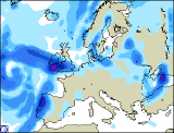 Sunday and Monday. Confidence is high (80%) for mainly dry and cold conditions for the northern parts of the British Isles with thickening clouds after early morning fog. Isolated showers far north. However, heavy rain is pushing north across central southern parts of the UK & Ireland. We expect significant downpours from Wales to the North with more than 40mm of rain in 12hrs during Sunday. The rain will be accompanied by very strong to gale force easterly winds with significant wind chill effects. Some of it might even fall as sleet or snow on higher grounds. Later winds in the south will ease and swing into the south rasing temperatures, but still with some heavy and squally showers.
 Tuesday to Thursday. The northern British Isles are turning wet and cold with heavy rain or sleet with snow on high ground. Very cold east to northeast winds. Ireland, Wales, the southwest and especially the southeast will see much milder temperatures with coastal squally showers. Generally very unsettled. Many showers, most frequent acoss the western Bristish Isles on Wednesday and somewhat drier for E Ireland, Wales and England towards Thursday. But also cooler again.
Friday to Sunday. Confidence is moderate (40%) that it will turn a little more settled and drier again. Perhaps a little bit warmer by the end of the week.