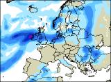
Long-range Outlook: 22/10/04 - 27/10/04
Low pressure dominating, giving rain or showers.
Click here for details of the weather over the next few days.
Please note that forecasting beyond five days is notoriously difficult, and small errors at short-range can lead to large deviations further in time. Our longer-range forecasts are based on the most accurate weather data available at the time, but alterations may be required as the period progresses. Please check back regularly for the most up-to-date forecast run.
Friday 22/10/04 to Saturday 23/10/04
After the rather chilly weather of late, it will become much milder across most of England and Wales on Friday, as winds swing round to the south. However, apart from sheltered eastern parts, there will be a lot of cloud around, with rain in places both early and late. Outbreaks of heavy rain will affect much of Ireland through the day, although Northern Ireland may start off bright. The best of any sunshine will be across Scotland, although southern parts will become wet towards evening. The milder spell will be very short-lived though, as temperatures return to near-normal values during Saturday. With a deep area of low pressure close to Ireland, fresh to strong west or south-westerly winds will affect most places. One band of heavy rain will clear away eastwards to be replaced by sunshine and occasional showers across England and Wales. However, the cloud and heavy rain will linger across much of Ireland, as well as Scotland where it will be rather chilly.
 Sunday 24/10/04 to Monday 25/10/04
With low pressure centred to the west of the UK on Sunday, the unsettled and rather windy conditions look set to continue. The most persistent and heavy rain will always be restricted to Ireland, Northern Ireland, southern Scotland and northern parts of England. To the north of this, it will be mostly dry with sunshine, but rather on the cold side. Remaining parts of England and Wales will have some brief sunny spells, but also a lot of cloud and the risk of scattered heavy showers. There won't be much change into Monday, except that the rain across Ireland will transfer slowly eastwards to affect western England and Wales through the day, heavy at times. Elsewhere, there should be some sunshine and times, but this will be frequently interrupted by showers, perhaps with hail and thunder. The best of any drier weather should be across eastern parts of England, and again across northern Scotland.
 Tuesday 26/10/04 to Wednesday 27/10/04
Staying rather unsettled everywhere on Tuesday, but most places will have a straight-forward day of sunshine and showers. The most frequent showers will be across western Scotland and Northern Ireland, and they will merge to give longer spells of rain. Elsewhere, there will be some sunshine, but developing showers will turn heavy with the risk of thunder once again. Eastern England may start rather wet though, with a lot of cloud lingering through the day. Yet more heavy rain will sweep in from the south-west during Wednesday, affecting much of Ireland, England and Wales through the day. Northern Ireland and Scotland will be somewhat brighter, but always with plenty of blustery showers around. Temperatures will remain around average, although in the brisk winds and the rain it won't feel very pleasant. Please check back for further forecast updates.