Weekly Outlook : 20/10/03-26/10/03
Cold & Unsettled. Wintry Showers in Places!
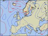 Monday 20/10/03 to Tuesday 21/10/03
A band of cloud and patchy rain will spread south across the Midlands, south Wales and southern England during Monday morning, clearing into the Channel during the afternoon. Behind this, becoming brighter with sunny spells, but a good deal cooler with temperatures in single figures across Scotland and Northern Ireland. There will be strong northerly winds, with plenty of showers in the north and east, some wintry even at low levels. During the evening and overnight, these showers will persist, spreading inland at times. By Tuesday morning, many parts will be dry after an overnight frost in places. Showers in the north-east will develop elsewhere, with hail and thunder, and increasingly turning to snow over high ground. The south and parts of southern Ireland stand the best chance of remaining dry, with sunny spells. The strong northerly winds will continue, making it feel bitterly cold, especially in the north.
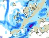 Wednesday 22/10/03 to Thursday 23/10/03
It will remain very unsettled on Wednesday, with showers or longer spells of rain everywhere. It will also remain rather cold, especially in the north and west with stiff east or north-easterly winds. Showers will be wintry in the north, with significant snowfall over the Scottish Mountains. Western parts of Ireland may be cloudier with persistent rain at times. The best chance of being dry will be in south-western parts of Wales and England. There will be little change overnight, with rain or showers continuing, although some central and southern parts may become mostly dry. Into Thursday, longer spells of rain, sleet or snow are expected in north-eastern parts, with sunshine and showers elsewhere, some heavy with hail and thunder. There will be strong to gale force easterly winds in northern parts, but it will be less windy, thus feeling less cold elsewhere.
Friday 24/10/03 to Sunday 26/10/03
Friday and the weekend are currently rather uncertain. One thing that can be assured however, is that it is likely to be very unsettled. The current detail indicates that Friday will be a wet day across southern parts, with spells of heavy rain at times. Northern parts will also be rather cloudy, with showery rain, wintry over high ground. There will be gale fore easterly winds here, making it feel cold. Elsewhere, it will be bright but with scattered showers. The weekend will continue to see a strong north-easterly flow, so generally cool everywhere. Northern parts will see the best of any sunny weather, although there is always the risk of showers. Southern areas are expected to stay mostly cloudy with spells of rain. As ever, more detail on the weekend in the next weekly update.