Long-range Outlook: 24/06/04 - 29/06/04
Unsettled with showers, but a brief return to summer this weekend.
Click here for details of the weather over the next few days.
Please note that forecasting beyond five days is notoriously difficult, and small errors at short-range can lead to large deviations further in time. Our longer-range forecasts are based on the most accurate weather data available at the time, but alterations may be required as the period progresses. Please check back regularly for the most up-to-date forecast run.
Thursday 24/06/04 to Friday 25/06/04
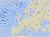
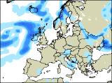
Thursday will be seeing the tail end of an unusually deep low pressure area, which will affect much of the UK on Wednesday. This tail end will give all parts a fresh northerly wind, perhaps gusting to gale force in eastern Scotland and north-east England for a time. Bands of showery rain will affect much of Scotland, central and eastern England, and Northern Ireland, some heavy with thunder. The rest of Ireland, Wales and south-west England will become mostly dry with some warm sunny spells. On Friday, the predominantly dry and bright weather will hang on in south-west England, south Wales and much of Ireland. However, with low pressure close to the north and east, the rest of England, much of Scotland and Northern Ireland will have a good deal of cloud and frequent showers. Some of the showers will be heavy with hail and thunder, and with a brisk north-westerly wind it will continue to feel rather cool.
 Saturday 26/06/04 to Sunday 27/06/04
On Saturday, there is every indication that high pressure in the south-west will build eastwards across much of the UK. This will give much of Ireland, England and Wales a mostly dry day with plenty of sunny spells. Temperatures will be around average, although it will feel pleasant in the sunshine. Conditions will remain rather more unsettled across Scotland and the far north of Northern Ireland however, with more cloud around and the risk of showery rain at times. Sunday may well see a brief return to summer across England and Wales, with low pressure to the west pumping warm southerly winds across these parts. With some long sunny spells, temperatures will lift into the mid to high twenties Celsius during the afternoon. Scotland will also become drier and brighter once any early showers die away. However, a trailing cold front will nudge slowly into much of Ireland from the west, bringing more cloud and the risk of showery rain, some heavy.
 Monday 28/06/04 to Tuesday 29/06/04
The hot, sunny weather will hang on across south-east England on Monday, but with the risk of thundery showers developing through the day. Elsewhere, the return to summer will have vanished already, as plenty of cloud gives outbreaks of showery rain. Some of the rain will be heavy, with the chance of thunder for a time. The rain will clear away from western Scotland and Northern Ireland however, followed by fresher weather with sunshine and showers. On Tuesday, heavy and thundery rain will affect south-east England for a time, but this will clear during the afternoon. Much of the UK will then be in fresher air, with some sunny spells. However, there will also be some hefty showers around, with the risk of hail and thunder. Later in the day, persistent rain will move into the north-west.