Long-range Outlook: 24/11/04 - 29/11/04
A wet but mild start. Colder with snow risk next weekend.
Click here for details of the weather over the next few days.
Please note that forecasting beyond five days is notoriously difficult, and small errors at short-range can lead to large deviations further in time. Our longer-range forecasts are based on the most accurate weather data available at the time, but alterations may be required as the period progresses. Please check back regularly for the most up-to-date forecast run.
Wednesday 24/11/04 to Thursday 25/11/04
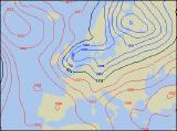
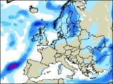
We're still expecting high pressure to remain close to the south of the UK on Wednesday, giving mainly dry conditions across England and Wales. However, there won't be much in the way of brightness, and the best of any sunny spells will be in the east. The coasts of south-west England and Wales will be subject to mist and low cloud with the risk of drizzle. Across Ireland, Northern Ireland and much of Scotland, thicker cloud will give outbreaks of rain for much of the day, together with a fresh south-westerly wind. Very mild everywhere. There will be something of a change on Thursday, as more active weather fronts spread eastwards. Outbreaks of heavy rain will affect much of Ireland and western Scotland through the morning, transferring eastwards to much of Wales, northern England and the Midlands through the afternoon. The south-east should remain mostly dry and bright. South-west winds turning westerly as cooler air arrives later.
 Friday 26/11/04 to Saturday 27/11/04
During Friday, low pressure in the North Sea will drag a fresh west to north-westerly wind across most of the UK and Ireland. There'll be plenty of heavy showers across Ireland, Northern Ireland and Scotland, merging to give some longer spells of rain at times. For England and Wales, there will also be some showers, particularly in the west, but some eastern areas will remain dry and bright. The weather for Saturday is currently rather uncertain, but current indications suggest that a northerly flow will develop across the UK. Most of England and Wales will have showery rain at times, perhaps turning to snow over the high ground of north Wales and northern England. Scotland and Northern Ireland will become colder but much brighter with some sunshine. A scattering of showers will affect north-facing coasts though, these turning increasingly to sleet and snow as the day wears on.
 Sunday 28/11/04 to Monday 29/11/04
With Saturday's uncertainties, Sunday will also be something to watch. The northerly wind looks set to continue, but there will be a lot of cloud around. Bands of showery rain are expected to travel southwards across the country, turning to sleet and snow in the north and even further south over the higher ground. The best of any sunny spells will be across western parts of Ireland and Northern Ireland. Monday looks like staying rather cold, with the ongoing risk of sleet and snow. The most substantial snowfall will always be over the high ground of Scotland and northern England, but the risk will extend to lower levels even further south. This wintry outlook may well change in detail over the next few days, so please check back for further forecast updates.