Long-range Outlook: 24/10/05 - 29/11/05
A Wintry Blast! Snow Likely!
Click here for details of the weather over the next few days.
Please note that forecasting beyond five days is notoriously difficult, and small errors at short-range can lead to large deviations further in time. Our longer-range forecasts are based on the most accurate weather data available at the time, but alterations may be required as the period progresses. Please check back regularly for the most up-to-date forecast run.
Thursday 24/11/05 to Friday 25/11/05
After a cold and frosty spell across the UK and Ireland, winter looks set to deal a more significant blast from the north. This process will begin during Thursday, as low pressure aligns itself to the north-east of the UK. Outbreaks of rain will spread southwards across England, Wales and the Irish Republic during the day, heavy at times. As it clears, it will turn to snow across the higher ground of northern England and north Wales. Behind the rain across Scotland, it will be brighter with some sunshine, but also much colder. Strong to gale force northerly winds will blow in plenty of showers, many wintry with snow falling to sea-level by the end of the day. Some significant snowfall will occur over northern hills during Thursday night. On Friday, everywhere will be colder again with some sunny spells, but also showers. The most frequent showers will be across northern and eastern Scotland, eastern England, Northern Ireland and north Wales. Most will be wintry, with a mixture of rain, sleet, snow and hail, with accumulations of snow likely in places. Blizzard conditions are expected across the hills and mountains in Scotland, and the higher ground of northern England later. The driest, sunniest conditions will be in sheltered south-western areas.
 Saturday 26/11/05 to Sunday 27/11/05
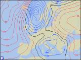
On Saturday, the low pressure is expected to drift across central and southern England, allowing a cold east to north-easterly flow to move in. Western areas will once again have the best of any sunshine, and across western Ireland in particular, it will remain dry. Elsewhere, the showers will be wintry again, and in southern and eastern England, temporary snowfalls are likely to accumulate. There is a hint of milder air creeping into Scotland and northern England, turning the showers more to sleet and rain. On Sunday, more persistent rain and sleet, with snow over the hills, will affect Scotland and Northern Ireland. Across the rest of England and Wales, there will be a mixture of sunny spells and showers. Most of the showers will be around eastern and southern coasts, although any sleet or wet snow will be restricted to the highest ground by this time. A fresh to strong easterly wind will make it feel particularly chilly across England and Wales.
 Monday 28/11/05 toTuesday 29/11/05
The UK and Ireland will remain under the influence of low pressure during the start of the new week, with Monday seeing a good deal of cloud. Showers or longer spells of rain will affect many areas, and this will once again fall as snow above about 500m, affecting north Wales, northern England and Scotland. Milder across Ireland and Northern Ireland, although with an increasing breeze and overcast skies, it will feel rather chilly. On Tuesday, colder air will start to work southwards across Scotland again, but it will be a slow process. The rain will start to turn to sleet and snow once again, falling to increasingly lower levels in the north later. Across the rest of the UK and Ireland, milder air will slowly move up from the south, with brighter skies reaching southern areas later. Elsewhere, despite the milder conditions, it will be cloudy with showers or longer outbreaks of rain. With the particularly tricky winter scenario in the near future, please check back for further forecast updates.