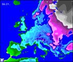
Long-range Outlook: 25/01/06 - 31/01/06
Much Colder! Snow in East.
Click here for details of the weather over the next few days.
Please note that forecasting beyond five days is notoriously difficult, and small errors at short-range can lead to large deviations further in time. Our longer-range forecasts are based on the most accurate weather data available at the time, but alterations may be required as the period progresses. Please check back regularly for the most up-to-date forecast run.
Wednesday 25/01/06 to Thursday 26/01/06
Just about every forecast model is suggesting that the UK and Ireland will become much colder at some point next week, with the potential for a prolonged period of cold weather. Where they disagree, is when this will happen. For Wednesday at least, we're expecting the cold to hold off to the east of the UK, with high pressure across the country. That said, it will still be colder than recently, with temperatures generally below average. After morning frost and fog, most of England, Wales and Scotland will be dry with some sunshine. Ireland and Northern Ireland will have a similar day, although there may be a little more cloud around. On Thursday, the repositioning of the high suggests an east to south-easterly wind will develop, and this will start to draw in colder air. Fog and frost could linger all day across parts of England and east Wales, but the rest of the UK and Ireland will have sunny spells for much of the day. Towards evening, there will be a risk of one or two very isolated wintry showers on the East Coast of England, as cloud increases.
 Friday 27/01/06 to Saturday 29/01/06
At present, Friday looks set to be the day with the first of the really cold air moves in, as biting easterly winds blow in all the way from eastern Europe. For much of the UK and Ireland, after a hard frost to start, it will be dry with a few sunny spells, but also a fair amount of low cloud floating around. Eastern parts of England will have very light snow flurries at first, and these will become heavier and more frequent during the afternoon. Snowfall amounts won't be substantial, but there may be a light covering in places, especially in south-east England and East Anglia. On Saturday, model output is in strong disagreement, as to whether mild conditions will return. However, we believe there is enough evidence in place to suggest that the cold weather will continue, with easterly winds blasting across the UK. Once again, most places will be cold and frosty overnight, but with dry conditions and some brightness by day. However, snow showers in eastern England will move further inland into the Midlands, with a risk of more prolonged sleet and snow in the south later. Temperatures barely above freezing.
 Sunday 30/01/06 to Monday 31/01/06
Confidence is currently very low for the weather on Sunday and Monday, as the slightest shift in the wind direction can make all the difference. Indications are that it will remain cold, with south-easterly winds, although perhaps not quite as cold as earlier in the weekend. Eastern and south-eastern areas will still be at risk from snow showers, whilst many other areas remain dry and bright. Later on Monday, as Atlantic weather fronts attempt to push in from the west, western parts of Ireland and Northern Ireland could be at risk from spells of rain turning readily to sleet and snow. However, for a more detailed outlook on next weekend and beyond, please check back for further forecast updates.