Weekly Outlook : 21/05/03-27/05/03
Rain or Showers - Unsettled May Continues!
 Wednesday 21/05/03 to Thursday 27/05/03
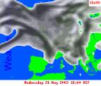
The unsettled theme continuing on Wednesday, with fronts spreading up from the south-west during the morning. Many northern and eastern parts will have a dry morning however, with some sunny spells. Rain in the south-west will spread steadily north-eastwards, reaching the Scottish borders and north-east England by midnight. Some of the rain will be heavy around western coasts and hills, but it will clear southern England towards evening. Mild in the south, cooler in the north with fresh to strong westerly winds. Overnight and into Wednesday, rain will grind to a halt across Wales and central England, retreating back southwards during the afternoon. Ireland, Scotland and the rest of England will have bright spells and heavy showers, some with hail and thunder. Winds will be strong in the west, gusting to gale force through the Irish Sea. Warm in the south-east at first, but the cooler weather returning during the afternoon with the rain.
 Friday 23/05/03 to Saturday 24/05/03
Another very unsettled day on Friday, with an intense low pressure system to the north-west. This will bring strong west to north-westerly winds, gusting to gale force around some heavy showers. The showers developing widely during the afternoon, some with hail and thunder, and merging into bands crossing the country at times. The far south and east may escape with a bright afternoon and only scattered showers. Cool in many parts, especially in the north and west. More organised cloud and rain will spread from the north-west during Saturday morning, reaching Wales and the north Midlands in the afternoon. To the north another day of sunshine and heavy showers, thunderstorms and gusty winds. The winds will be from a northerly direction so feeling much cooler, and showers may turn wintry over the highest ground. For southern England, showers developing after a bright start, heavy and slow moving in lighter winds.
 Sunday 25/05/03 to Tuesday 27/05/03
The latter part of the weekend and early part of next week looks to be unsettled once more. However, with low pressure centred to the south-east of the UK, winds will swing round to an easterly direction. Heavy showers look set to develop in eastern and south-eastern parts on Sunday, spreading westwards during the afternoon. Most parts will see sunny spells as well however. The scenario into next week looks like seeing much warmer conditions spreading in from the south-east, although still generally unsettled with the chance of further showers. This however is rather uncertain at the moment, and should this easterly set-up be established the exact location of rainfall is currently uncertain. Further updates will follow.