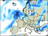
Long-range Outlook: 24/05/05 - 29/05/05
Rain or showers. Temporarily warm in south-east.
Click here for details of the weather over the next few days.
Please note that forecasting beyond five days is notoriously difficult, and small errors at short-range can lead to large deviations further in time. Our longer-range forecasts are based on the most accurate weather data available at the time, but alterations may be required as the period progresses. Please check back regularly for the most up-to-date forecast run.
Tuesday 24/05/05 to Wednesday 25/05/05
The unsettled weather will continue into Tuesday, with low pressure dominating the scene. England and Wales will have a cloudy start, with outbreaks of rain spreading eastwards. Some of this rain will be heavy, with strong westerly winds through the Channel. However, brighter weather with sunny spells and scattered blustery showers, already across Ireland during the morning, will follow the rain to Wales and western England later. Western Scotland and Northern Ireland will also have a mixture of sunshine and heavy showers, but eastern Scotland is likely to remain grey and wet for much of the day. Temperatures close to, or a little below average. Another low pressure area will move in from the south-west on Wednesday, but this will mark the start of a change. During the day, Northern Ireland and Scotland will have sunny spells and scattered showers. However, the rest of Ireland, England and Wales will be cloudy with some heavy rain, perhaps thundery. The exception will be south-east England, where it will be bright, and southerly winds will start to draw in warm air from France.
 Thursday 26/05/05 to Friday 27/05/05
A huge depression will sit to the west of Ireland during Thursday. For most of Ireland and Northern Ireland, as well most of Wales, northern England and Scotland, it will be a very wet day. Pulses of rain running northwards will give locally torrential downpours, with a risk of thunder. However, it will be a very different day for the Midlands, East Anglia and southern England. Although there could be quite a lot of cloud, there will also be some sunny spells. Southerly winds will bring in some warm air, and it may well feel humid with highs perhaps reaching 22 or 23C. During the first part of Friday, the far south-east of England could become potentially very warm, with highs of 25C. However, this is uncertain at present, as the cloud and rain further west will be moving eastwards rapidly. In fact, the low pressure responsible for the rain may well become unusually intense to the north of Ireland, giving a risk of coastal gales in western Scotland and Northern Ireland. Heavy and persistent rain will also affect much of the north, but it will become more showery across the south later.
 Saturday 28/05/05 to Sunday 29/05/05
The start of the weekend will remain very unsettled, with strong westerly winds in the north making it feel cool. Outbreaks of rain, often heavy, will affect Scotland and Northern Ireland for much of the day. This rain will drift southwards to affect the rest of Ireland later as well. However, despite it feeling cooler than of late, England and Wales will only have a few showers, with some decent sunny spells. Things look like staying rather unsettled during Sunday, with a good deal of cloud around. However, showers will be fairly scattered, so many areas could remain dry throughout the day, with one or two brighter spells. Temperatures will once again be around average, perhaps slightly above in southern areas. Please check back for further forecast updates on next weekend's weather.