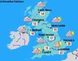
Long-range Outlook: 24/06/05 - 29/06/05
Showers or rain, especially in the south.
Click here for details of the weather over the next few days.
Please note that forecasting beyond five days is notoriously difficult, and small errors at short-range can lead to large deviations further in time. Our longer-range forecasts are based on the most accurate weather data available at the time, but alterations may be required as the period progresses. Please check back regularly for the most up-to-date forecast run.
Friday 24/06/05 to Saturday 25/06/05
After another hot spell mid-week, especially in the south, Friday will see a break down to cooler conditions. This breakdown is currently looking rather a violent one, with heavy downpours and thunderstorms developing across much of central and eastern England. Locally torrential falls of rain are possible, with a risk of hail. Across Scotland, Wales and south-west England, showers will be lighter and more scattered, and it will already be turning cooler here. After a bright start, cloud and showery rain will spread eastwards across Ireland and Northern Ireland, although it will turn lighter as it reaches eastern areas. By Saturday, the cooler and fresher conditions will have reached all parts of the UK, although the south-east of England may start rather muggy with thundery showers. High pressure building from the north-west will maintain a cool northerly breeze for many, but it will keep conditions largely dry with some sunshine across Scotland and Northern Ireland. Cloud across Ireland, Wales and the rest of England could threaten a few showers, but there will be some sunny spells too.
 Sunday 26/06/05 to Monday 27/06/05
On Sunday, humid and muggy air looks set to try and move northwards from France, although it will never reach the south coast during daylight hours. It will, however, force cloud and showery rain across southern England, and some of this could be heavy with a risk of thunder. For the Midlands, East Anglia and Wales, it will stay fresher with sunny spells and just the outside risk of a light shower. The best of the sunshine will be across Scotland and Ireland, as high pressure continues to dominate. Heavy and potentially thundery rain will spread northwards across the Midlands and Wales on Sunday night, and this will make for a wet morning across most of England and Wales, with the exception of northern England. The rain will also affect southern counties of Ireland, with more cloud streaming northwards ahead of this. Northern Ireland will escape with another bright day with sunny spells, as will most of Scotland and Northern Ireland. Remaining fresh but pleasantly warm here, whilst southern areas become rather humid once again.
 Tuesday 28/06/05 to Wednesday 29/06/05
With low pressure anchored to the south-west of the UK, most of England and Wales will have a cloudy day on Tuesday, with outbreaks of rain and drizzle. It will be gloomy and misty along southern coasts, and over the hills elsewhere. Rain will also affect most of Ireland, perhaps spreading into southern counties of Northern Ireland during the afternoon. However, to the north of this it should remain dry with some hazy sunshine, and it will be very similar across Scotland. Perhaps the best of the sunshine will be across Shetland. Remaining rather cloudy with a risk of showers on Wednesday, and even the sunshine across Scotland will be less reliable. However, confidence at this early stage is low, so please check back for forecast updates for the latter part of next week and beyond.