Long-range Outlook: 24/09/05 - 29/09/05
Unsettled. Potentially stormy early next week.
Click here for details of the weather over the next few days.
Please note that forecasting beyond five days is notoriously difficult, and small errors at short-range can lead to large deviations further in time. Our longer-range forecasts are based on the most accurate weather data available at the time, but alterations may be required as the period progresses. Please check back regularly for the most up-to-date forecast run.
Saturday 24/09/05 to Sunday 25/09/05
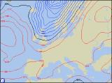
Southern and eastern parts of England will have a rather cloudy start to Saturday, with showery rain. This should clear away during the afternoon. For the rest of England, Wales and eastern Scotland, the day will kick of to a dry start with some sunshine. However, a deep area of low pressure to the west of the UK will already be spreading cloud and rain across most of Ireland and western Scotland, and this will reach western parts of England and Wales by evening. Some of the rain will be heavy, and will be accompanied by gale force winds around the coasts of Scotland, and through the Irish Sea. This large Autumn storm will be to the north of Scotland by Sunday, continuing the strong to gale force winds across northern Scotland. Morning rain will clear from eastern parts of the UK, leaving behind sunshine and showers. The showers will be most frequent in the north and west, where many will be heavy with hail and thunder. Later in the afternoon, more persistent rain will return to Ireland. Feeling cooler everywhere.
 Monday 26/09/05 to Tuesday 27/09/05
The UK and Ireland will remain in a very mobile west to southwesterly flow on Monday, as low pressure stays put to the north of Scotland. There will be some rain around during the morning across England and Wales, but this should clear northwards. Behind this, it will become humid with low cloud and drizzle in south Wales and southwest England, whilst some brighter spells are likely to the lee of any high ground. Rain is expected to continue throughout the day in Scotland and Ireland, becoming heavy again across Northern Ireland after easing temporarily. Remaining breezy, with gales later in southwest Ireland. We're expecting some potentially severe weather across parts of Scotland and Northern Ireland during Tuesday, as a particularly intense depression sweeps to the north of Scotland. Gales or severe gales are likely, with the potential for storm force winds across the coast of northern Scotland. As well as the winds, some heavy rain will affect many northern and western areas. England and Wales will have some sunny spells, but even here it will turn wet by evening.
 Wednesday 28/09/05 to Thursday 29/09/05
The weather during Wednesday very much depends on the track of the large Autumn storm during Tuesday. However, indications suggest that the low, retreating towards Scandinavia, will open the door for strong north-westerly winds right across the UK. High pressure to the west should give Ireland and Northern Ireland some sunshine, with the showers slowly dying away. However, showers will affect many other parts of the UK throughout the day, perhaps with more persistent rain proving slow to clear from eastern England. Turning much cooler. As the large area of high pressure continues to build across the UK and Ireland on Thursday, the weather will improve throughout the day. Indeed, most of Ireland, western Scotland, Wales and western parts of England will be dry and sunny after a chilly start. However, eastern Scotland and England will have more cloud, with showers only slowly easing through the afternoon. More details on the potentially severe weather early next week will be given in the next forecast update.