Long-range Outlook: 26/08/05 - 31/08/05
Low after low providing rain for all.
Click here for details of the weather over the next few days.
Please note that forecasting beyond five days is notoriously difficult, and small errors at short-range can lead to large deviations further in time. Our longer-range forecasts are based on the most accurate weather data available at the time, but alterations may be required as the period progresses. Please check back regularly for the most up-to-date forecast run.
Friday 26/08/05 to Saturday 27/08/05
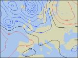
After a week of rather autumnal weather across the UK and Ireland, Friday is currently looking equally unsettled for many. A transient ridge of high pressure should give England and Wales some dry and bright weather, although cloud will increase later. As westerly winds topple across the top of the high, Scotland will have a rather more cloudy day, with rain and drizzle in western and northern upland areas. After a dry start, a small area of low pressure will develop and swing eastwards across Ireland through the afternoon, giving some heavy rain in southern areas. However, Northern Ireland should remain essentially dry, if rather cloudy. This small orbital low will continue its journey eastwards on Saturday, giving central and southern parts of England and Wales a fairly wet day with patchy rain and drizzle. Although there will be a lot of cloud, the rest of England and Wales will be drier and brighter. Ireland and Northern Ireland will cloud over as a warm front encroaches from the west during the day. Similarly across Scotland, skies will become cloudier after a dry and bright start. Breezy and fairly cool across all areas.
 Sunday 28/08/05 to Monday 29/08/05
As another small but intense depression skirts eastwards to the north of Scotland on Sunday, there will be a risk of gales around the coasts and over the hills. As well as these strong winds, another cold front is expected to give a spell of rain across the UK during the day, always heaviest in Scotland, Northern Ireland and northern England. In fact, the east Midlands, East Anglia and south-east England could remain dry and bright, if somewhat cloudier later. After a wet start, skies will brighten across Ireland and Northern Ireland, although fresher winds will blow in a few showers from the west. Monday looks set to start dry and bright across many central and eastern parts of England and Wales, but it won't be long before more rain sweeps in from the west. This rain will already be giving most of Ireland and Scotland a soaking during the morning, and across the Irish Republic in particular, it could last for most of the day. At least the winds are expected to be quite light across the UK and Ireland, so it will feel somewhat less cool than recently.
 Tuesday 30/08/05 to Wednesday 31/08/05
Model output is suggesting that high pressure will attempt to build northwards from the near continent on Tuesday, resulting in an improvement in the weather across southern England and south Wales. There won't be much in the way of sunshine, but at least it should become dry. On the other hand, low pressure across Scotland will maintain the very autumnal conditions elsewhere, with heavy rain affecting much of Ireland, Northern Ireland and northern England, clearing to showers later in Scotland. Feeling cool in the north, especially in strong westerly winds. On Wednesday, very little looks set to change, with more cloud and rain sweeping across central and northern areas. The south should just about remain dry as high pressure sits close-by, but any sunny spells will be restricted to the south coast and the Channel Isles. Please check back for further forecast updates, refining the weather outlook for next week.