Long-range Outlook: 24/12/04 - 29/12/04
A decidedly festive outlook! Snow for some!
Click here for details of the weather over the next few days.
Please note that forecasting beyond five days is notoriously difficult, and small errors at short-range can lead to large deviations further in time. Our longer-range forecasts are based on the most accurate weather data available at the time, but alterations may be required as the period progresses. Please check back regularly for the most up-to-date forecast run.
Christmas Eve 24/12/04 to Christmas Day 25/12/04
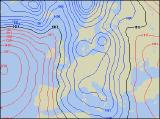
For an in-depth look at the weather over Christmas, please visit here. This Friday, a complex area of low pressure across the North Atlantic will give a strong north-westerly flow right across the UK and Ireland. Embedded in this flow will be plenty of showery troughs, and even some longer outbreaks of rain. Sleet and snow showers will become increasingly frequent across parts of Scotland and Northern Ireland, and not just on the high ground. Conditions will be somewhat less cold across England, Wales and Ireland, and most of the showers will be of rain or sleet. On Christmas Day, winds will have swung around to the north across the northern half of the UK, bringing in some very cold air. Confidence is steadily increasing that much of Scotland, northern England and Northern Ireland will have showers or hail, sleet and snow, with many places attaining the accolade of a White Christmas. All is not lost across England and Wales, especially across north Wales, northern England and the Midlands. Wintry showers will fall here through the day, with the risk of snow accumulating even at low levels. However, southern areas are expected to be mostly dry and bright, but rather cold. Please note that, even at this stage, detail is difficult and minor changes may occur.
 Boxing Day 26/12/04 to Monday 27/12/04
With the Christmas festivities ongoing, the cold weather looks set to stay on Boxing Day as well. Low pressure to the north will maintain the strong north to north-westerly wind, bringing in plenty of heavy snow showers. Most of these will affect northern and western Scotland, northern Ireland, north-west England and north Wales, with a further cover likely in places. There will be some sunshine elsewhere, but we're expecting some troughs to spread southwards across all parts, bringing the risk of prolonged sleet and snow to many areas through the evening. On Monday, as the low drifts down the North Sea, winds will continue to blast from the north. Blizzard conditions may occur over upland parts of Scotland and northern England, and snow showers will pentrate right down into southern parts of the UK and Ireland. Some inland areas may miss most of the showers and have some crisp sunshine, and there'll be more emphasis on snow across the eastern parts of England.
 Tuesday 28/12/04 to Wednesday 29/12/04
Tuesday looks like being the big change day at present, as milder air tries to move in from the west. Eastern parts of England and Scotland will still have some snow showers during the morning, but elsewhere the winds will turn westerly and skies will turn overcast. Outbreaks of heavy rain will sweep east across Ireland and Northern Ireland, and as this reaches western Scotland, Wales and south-west England through the afternoon, it will turn readily to sleet and snow. Wednesday will be milder and windier everywhere, with the last of the rain and snow clearing from eastern parts. However, another wave depression will bring lots of heavy rain across central and southern parts of Ireland, England and Wales during the afternoon, together with strong winds. As ever,