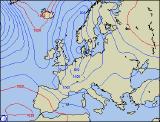
Weekly Outlook : 24/01/04 - 30/01/04 B
Becoming very wintry with the risk of snow!
 Saturday 24/01/04 to Sunday 25/01/04
Saturday will be the last of the mild days across central and southern England, together with Wales and much of Ireland, with early rain clearing to sunny spells. Scattered showers may affect parts of North Wales and north-west England, blown in on a fresh north-westerly wind. Northern Ireland and much of Scotland will have sunny spells and showers, the showers becoming increasingly wintry as the colder air begins to sink down from the north. Overnight, showers will fall as snow across many northern parts, but elsewhere mostly dry with a slight frost. On Sunday, Scotland and Northern Ireland will become cloudy with outbreaks of sleet and snow, giving large accumulations even at lower levels as a northerly wind sets in. Northern parts of England, Wales, the north Midlands and northern parts of Ireland will be mostly dry with only scattered wintry showers. Southern England and south Wales will become cloudy with outbreaks of rain, turning to sleet and snow on its northern edge with the risk of accumulation in places. Light winds in the south, gales later in the north.
 Monday 26/01/04 to Tuesday 27/01/04
Remaining rain, sleet and snow will clear away from south-east England, then many southern parts of England, Wales and Ireland will have a dry day with sunny spells. Much of Northern England, Northern Ireland and Scotland will have heavy, frequent showers, falling predominently as snow even at lower levels. Eastern coasts of England will also have snow showers during the afternoon, giving the risk of disruption. A fresh to strong northerly wind will blast across all parts, making it feel bitterly cold. Overnight, snow showers will continue in the north and east, but elsewhere turning clear and cold with a hard frost. Tuesday will be another wintry day, perhaps with some of the most severe winter weather for some parts for a number of years. Strong northerly winds will bring almost persistent spells of snow to much of Scotland, down eastern coasts of England and parts of Northern Ireland. The showers may drift further inland at times, giving substantial accumulations over high ground. Western parts will be dry with sunny spells, but with temperatures close to, or below freezing everywhere, it will be a bitter day.
 Wednesday 28/01/04 to Friday 30/01/04
Wednesday will see a continuation of the wintry weather, with further heavy snow showers across many northern and eastern parts. Once again, the south and west will have the best chance of staying dry and bright, but bitterly cold everywhere with a penetrating frost overnight. Thursday will see the strong northerly winds easing across western parts, but only as more persistent spells of sleet and snow affect much of Northern Ireland, and western parts of Scotland. Eastern parts of England and Scotland will again have heavy snow showers, but central parts should remain dry and bright. By Friday, the heaviest snowfall will transfer to south-east England, with further risk of disruption. Western parts will become moslty dry and bright, but once again it will remain cold. Further updates will be issued on Sunday regarding the potentially severe outlook.