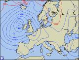
Weekly Outlook : 23/04/03-29/04/03
Settled At First. Rain/Showers From Thursday Onwards.
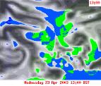 Wednesday 23/04/03 to Thursday 24/04/03
Another largely settled day to come on Wednesday, with high pressure very much in control. From the word go, after a misty start England and Wales will see sunny spells for most of the day, allowing maximum temperatures to reach between 17°C and 20°C. It will be cooler around the coasts with sea breezes, and also across Scotland and Ireland where cloud will bubble up during the afternoon, perhaps the outside chance of a shower. By Thursday, conditions will still remain largely settled across central and northern parts, with highs of 16°C-18°C in the sunshine. Across the south-west however, cloud will increase as fronts spread in from the Atlantic. By afternoon rain will reach many parts of southern England, possibly south Wales, some heavy. Winds will increase across Cornwall and southern parts of Ireland, gusting to 50mph in places. The rain will reach southern Scotland by midnight, with heavy showers following behind.
 Friday 25/04/03 to Saturday 26/04/03
A very unsettled spell of weather compared to of late. During Friday remnant rain will linger across Scotland, while at the same time further fronts will spread north-eastwards across all parts. These will produce widespread, heavy rain and will be replaced later by blustery, thundery showers across England and Wales. Feeling cooler also, especially in the strong southerly winds which will gust to gale force in exposed parts of the far west. Rain should clear the far north during Saturday, however southern and eastern England will see further pulses at times. Out to the west, showers will build and spread eastwards, some heavy and possibly thundery. Winds will ease somewhat, but will still be gusty in and around the heavier showers. Maximum temperatures ranging from 12°C in the north, 16°C in the south.
 Sunday 27/04/03 to Tuesday 29/04/03
Remaining unsettled for the latter part of the weekend and into next week. Fronts will cross the country from west to east, bringing spells of rain, heavy at times. Between these rain bands there will be some dry, bright weather, especially in the east. However, with the brighter weather will be a scattering of showers, often heavy with thunder. Winds will be strong at times, at their peak in the west and south-west during later Sunday and into Monday morning. By the end of Tuesday, things look set to become a little more settled with fewer showers and lighter winds. This is still a long way off however, and forecasts will be updated in due course.