Weekly Outlook : 23/05/03-29/05/03
Unsettled N&W. Drier/Brighter in S Next Week
 Friday 23/05/03 to Saturday 24/05/03
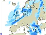
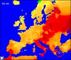
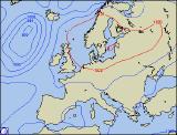
Low pressure in the north-west will continue to dominate the weather across all parts. Fronts, gradually clearing away will bring a mostly cloudy morning across southern and eastern England, with spells of light rain. Cloud and rain also returning to north-western parts, heavy at times and accompanied by a strong westerly wind. For remaining areas, a few bright spells but always a lot of cloud around with showers, some heavy at times with thunder. Feeling rather cool for the time of year in the brisk wind, but overnight many of the showers will die away. Into Saturday, these winds will shift to a north-westerly, driving bands of heavy showers south-eastwards across most parts. Some will contain hail and thunder, and will merge to give more persistent rain in the north-west. South-eastern parts may just escape with a dry day, with sunny spells from time to time. Remaining rather cool in most places, around average in the south.
 Sunday 25/05/03 to Monday 26/05/03
A straight forward run of west to north-westerly winds on Sunday, bringing a mix of sunny spells and showers. The showers will be most frequent across the north and west, some merging into bands with hail and thunder. Southern parts may escape the worst of the showers with more in the way of sunny spells, so feeling milder here. The far west of Ireland will remain largely cloudy, as weak fronts move in slowly from the west. Southern parts are likely to remain mostly dry during Monday also, and turning slightly warmer in prolonged sunny spells. Elsewhere, showers from the word go across western parts will be carried inland by stiff westerly winds. Some will again be heavy, with the chance of hail and thunder. Temperatures around average or slightly below in the north and west.
 Tuesday 27/05/03 to Wednesday 29/05/03
A spilt is likely in the weather during the middle of next week, with low pressure still governing the weather in the north, but high pressure slowly building across southern parts. This anticyclone is likely to bring sunny spells to southern England and Wales, particularly by Wednesday when it will begin to turn much warmer. Northern England, Northern Ireland and Scotland will still see heavy showers or longer spells of rain, as westerly winds remain strong. Remaining cool here, but as ever, further detail will be included in the next weekly update.