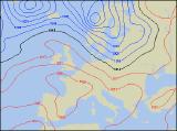
Long-range Outlook: 27/09/04 - 02/10/04
Often unsetted. Best warmth and sunshine in the south.
Click here for details of the weather over the next few days.
Please note that forecasting beyond five days is notoriously difficult, and small errors at short-range can lead to large deviations further in time. Our longer-range forecasts are based on the most accurate weather data available at the time, but alterations may be required as the period progresses. Please check back regularly for the most up-to-date forecast run.
Monday 27/09/04 Tuesday 28/09/04
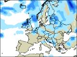
The new week will start breezy and rather cool across most places. Showery rain across southern England and south Wales during Monday morning will push away southwards, leaving behind some sunny spells right across the UK and Ireland. It'll feel fairly cool in a brisk north-westerly wind though, and this will feed in a number of heavy showers across parts of northern and eastern Scotland, as well as north-east England. However, most places will turn dry overnight and under mostly clear skies it will turn cold enough for a touch of ground frost almost anywhere. By Tuesday, a band of thicker cloud will have moved across much of the Irish Republic, although any rain will mostly die out. Across the rest of Northern Ireland and Scotland, it will be largely dry with some sunshine, and only an isolated shower. With high pressure firmly building, England and Wales will stay dry and sunny, and it will feel pleasantly warm here in the light winds.
 Wednesday 29/09/04 Thursday 30/09/04
Tuesday's settled conditions will just about hang on across a large part of England and Wales on Wednesday, with more sunny spells. Northern parts of Wales and north-west England will turn more cloudy though. A very different day across most of Ireland and Scotland, as weather fronts bring cloud and occasional rain in off the Atlantic, together with a freshening westerly wind. Temperatures will be around average everywhere, although in the sunshine across the south it will feel pleasant. As winds turn more southerly on Thursday, there is the potential for some much warmer weather across southern and eastern parts of the UK, together with some sunny spells. Elsewhere, with westerly winds there will be more cloud around. This may be thick enough across Ireland, Northern Ireland and western Scotland for some mostly light rain. Feeling cooler in the north-west too, with near-normal temperatures across central parts.
 Friday 01/10/04 & The Weekend
On Friday, the southerly winds will continue across a large part of the UK, making it feel especially warm across eastern parts of England with some sunshine. However, there will be lots of cloud elsewhere, with some heavy and potentially thundery outbreaks of rain. The worst of this will be across Ireland during the morning, where gales are likely for a time. On Saturday, this rain will have become lodged across most of the UK, as a deep area of low pressure moves slowly northwards to the west of Scotland. Heavy rain is likely almost anywhere, although it will be lighter and more patchy in the south. Very windy, with the risk of gales in the north-west. On Sunday, there's every liklihood that England and Wales will become mostly dry with some sunshine. However, Scotland and most of Ireland will stay wet with some heavy rain and strong winds. As ever, please check back for further forecast updates.