Long-range Outlook: 27/10/04 - 01/11/04
A stormy start. Turning more settled over the weekend.
Click here for details of the weather over the next few days.
Please note that forecasting beyond five days is notoriously difficult, and small errors at short-range can lead to large deviations further in time. Our longer-range forecasts are based on the most accurate weather data available at the time, but alterations may be required as the period progresses. Please check back regularly for the most up-to-date forecast run.
Wednesday 27/10/04 to Thursday 28/10/04
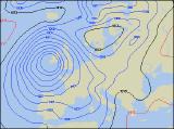
The forecast for Wednesday is currently causing concern, as an extremely vigorous depression looks set to approach the UK from the south-west. This will be monitored over the next few days, and this forecast will be updated accordingly. However, gale or severe gale force winds look set to reach southern and south-western parts of England, Wales and Ireland during Wednesday afternoon, together with some torrential bursts of rain. Rain will also affect Northern Ireland and western Scotland, but remaining parts of England, Wales and eastern Scotland will be mostly dry. During Wednesday night, the deep low is forecast to track northwards across Ireland, bringing the threat of severe gales to much of Wales, western England and eastern parts of Ireland and Northern Ireland. Thursday will start off extremely wet and windy across most of Ireland, western England and all of Wales, and the winds will only slowly ease through the day. The rest of the UK will also have spells of rain, but will be less windy.
 Friday 29/10/04 to Saturday 30/10/04
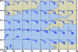
Although it will be less intense, the area of low pressure looks set to stay in place to the west of the UK on Friday, giving windy conditions across many parts. Once again, the strongest winds will be across western parts of the mainland UK, as well as parts of Ireland, with the continued risk of gales around Irish Sea coasts. Outbreaks of showery rain will affect Ireland and Scotland, but there should be some sunshine across England and Wales, in between the showers. Temperatures will be above average, although the winds will make it feel rather cool. Overnight and into Saturday, a brief ridge of high pressure will give more settled conditions across most of the country. Scotland and Ireland will have a chilly start, but apart from the odd shower it should stay dry through the day with some sunshine. England and Wales will also have some sunny spells, but southern and eastern areas will always have more cloud around, with the risk of showers.
 Sunday 31/10/04 to Monday 01/11/04
High pressure will remain across central and eastern parts of the UK on Sunday. However, across eastern parts of England and eastern Scotland, both during the morning and the evening, it may be a rather eery Halloween as dense fog patches form quite widely. However, during the day it should be a largely dry day with sunny spells for England and Wales. As winds freshen during the afternoon, much of Ireland, Northern Ireland and western Scotland will cloud over with the risk of rain later. It is looking likely that northerly winds will begin to set in across Ireland, Scotland and Wales during Monday, so it'll feel a good deal colder. It will also be rather cloudy with the risk of rain, perhaps turning wintry over the highest ground in the north. Most of England will still be influenced by high pressure, so after a rather frosty start it will be dry with some sunshine. Please check back for further forecast updates.